IMAGES TAKEN NEAR TO
Dabbs Hill Lane, NORTHOLT, UB5 4AG
Introduction
This page details the photographs taken nearby to Dabbs Hill Lane, UB5 4AG by members of the Geograph project.
The Geograph project started in 2005 with the aim of publishing, organising and preserving representative images for every square kilometre of Great Britain, Ireland and the Isle of Man.

There are currently over 7.5m images from over14,400 individuals and you can help contribute to the project by visiting https://www.geograph.org.uk
Image Map
Images are licensed for reuse under creativecommons.org/licenses/by-sa/2.0
Notes
- Clicking on the map will re-center to the selected point.
- The higher the marker number, the further away the image location is from the centre of the postcode.
Image Listing (20 Images Found)
Images are licensed for reuse under creativecommons.org/licenses/by-sa/2.0
Image
Details
Distance
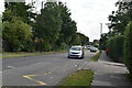
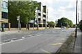
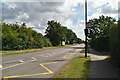
1
Doncaster Drive junction with Hurst Close
Image: © James Emmans
Taken: 17 Aug 2019
0.11 miles
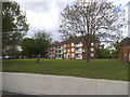
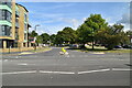
2
Doncaster Drive
Close to Northolt High School.
Image: © James Emmans
Taken: 17 Aug 2019
0.14 miles
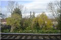
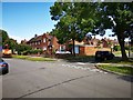
4
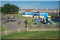
Northolt Recreation Ground
The blue buildings are the children's play centre in the north side of the Recreation Ground off Newmarket Avenue. The Recreation Ground has an interesting history insofar as it started life in 1929 as Northolt Racecourse specializing in the then new sport of pony racing. Extensive cantilever stands were built, and other facilities added during the 1930s included an electric totalizator, a totalizator stand, and an artificial watering system for softening the course. For a time the track was extremely popular, but racing ceased just after the outbreak of the Second World War, and the racecourse was taken over as an ordnance depot. Plans to re-open the racecourse after the war did not come to fruition, and much of it was eventually built over with housing, leaving only today's Recreation Ground. However the racing connection is remembered by some of the local road names such as Newmarket, Ascot, Kempton, Cheltenham, etc..
Image: © Nigel Cox
Taken: 22 Jun 2005
0.15 miles