IMAGES TAKEN NEAR TO
Craneswater, HAYES, UB3 5HP
Introduction
This page details the photographs taken nearby to Craneswater, UB3 5HP by members of the Geograph project.
The Geograph project started in 2005 with the aim of publishing, organising and preserving representative images for every square kilometre of Great Britain, Ireland and the Isle of Man.

There are currently over 7.5m images from over14,400 individuals and you can help contribute to the project by visiting https://www.geograph.org.uk
Image Map
Images are licensed for reuse under creativecommons.org/licenses/by-sa/2.0
Notes
- Clicking on the map will re-center to the selected point.
- The higher the marker number, the further away the image location is from the centre of the postcode.
Image Listing (75 Images Found)
Images are licensed for reuse under creativecommons.org/licenses/by-sa/2.0
Image
Details
Distance
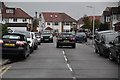
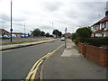
1
Houses on Craneswater
A small residential road parallel to the A4.
Image: © Bill Boaden
Taken: 26 May 2022
0.01 miles
5
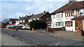
Houses in Craneswater
Alongside the A4.
Image: © David Martin
Taken: 17 Feb 2020
0.03 miles
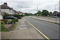
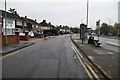
7
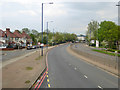
Eastbound A4, Bath Road
Houses on Craneswater are on the left.
Image: © Robin Webster
Taken: 22 Apr 2018
0.03 miles
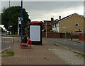
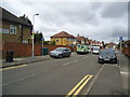
8
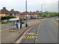
Eastbound A4, Craneswater bus stop
Craneswater is the parallel residential road.
Image: © Robin Webster
Taken: 22 Apr 2018
0.03 miles