IMAGES TAKEN NEAR TO
Phelps Way, HAYES, UB3 4LQ
Introduction
This page details the photographs taken nearby to Phelps Way, UB3 4LQ by members of the Geograph project.
The Geograph project started in 2005 with the aim of publishing, organising and preserving representative images for every square kilometre of Great Britain, Ireland and the Isle of Man.

There are currently over 7.5m images from over14,400 individuals and you can help contribute to the project by visiting https://www.geograph.org.uk
Image Map
Images are licensed for reuse under creativecommons.org/licenses/by-sa/2.0
Notes
- Clicking on the map will re-center to the selected point.
- The higher the marker number, the further away the image location is from the centre of the postcode.
Image Listing (6 Images Found)
Images are licensed for reuse under creativecommons.org/licenses/by-sa/2.0
Image
Details
Distance
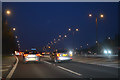
2
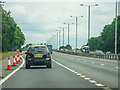
Hillington : M4 Motorway
Between Junction 4 (Heathrow Interchange) and Junction 3(Cranford Parkway Interchange).
Image: © Lewis Clarke
Taken: 18 Jul 2019
0.17 miles
3
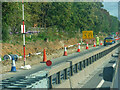
Cranford : M4 Motorway
The M4 Motorway between Junction 4 (Heathrow) and Junction 3 (Cranford Parkway).
Image: © Lewis Clarke
Taken: 12 Sep 2020
0.19 miles
5

Derelict building at Cranford Park
This derelict building lies on a footpath between the walled garden and the M4. This appears to be a structure that dates from after the demolition of Cranford House in 1945. A Geograph member remembers this building being used as a scout hut and the peeling paint above the roller door, the remains of which are still in existence.
Image: © MrC
Taken: Unknown
0.23 miles
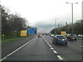
6
London Borough of Hillingdon : M4 Motorway
The M4 Motorway at Junction 3 (Cranford Parkway Interchange).
Image: © Lewis Clarke
Taken: 23 Mar 2018
0.24 miles