IMAGES TAKEN NEAR TO
Laburnum Road, HAYES, UB3 4JY
Introduction
This page details the photographs taken nearby to Laburnum Road, UB3 4JY by members of the Geograph project.
The Geograph project started in 2005 with the aim of publishing, organising and preserving representative images for every square kilometre of Great Britain, Ireland and the Isle of Man.

There are currently over 7.5m images from over14,400 individuals and you can help contribute to the project by visiting https://www.geograph.org.uk
Image Map
Images are licensed for reuse under creativecommons.org/licenses/by-sa/2.0
Notes
- Clicking on the map will re-center to the selected point.
- The higher the marker number, the further away the image location is from the centre of the postcode.
Image Listing (7 Images Found)
Images are licensed for reuse under creativecommons.org/licenses/by-sa/2.0
Image
Details
Distance
1
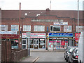
Cranford Parade
Row of shops on North Hyde Road, looking along Sutherland Avenue.
Image: © Oast House Archive
Taken: 14 Jul 2011
0.16 miles
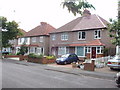
2
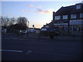
Shops on the corner of North Hyde Road and Roseville Road
Image: © David Howard
Taken: 7 Dec 2011
0.17 miles
4
North Hyde Road intersection with Wyre Grove
Image: © Stuart Logan
Taken: 11 Apr 2013
0.20 miles
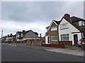
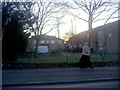
6
Nestles Avenue
Nestles Factory entrance is just to the left
Image: © J Taylor
Taken: 19 Nov 2008
0.21 miles
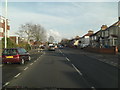
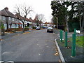
7
Houses in Nestle's Avenue
Near the end of this road where it is blocked to traffic - the entrance to the Nestlé factory is in North Hyde Gardens.
Image: © David Hawgood
Taken: 18 May 2008
0.23 miles