IMAGES TAKEN NEAR TO
Hanover Circle, HAYES, UB3 2TJ
Introduction
This page details the photographs taken nearby to Hanover Circle, UB3 2TJ by members of the Geograph project.
The Geograph project started in 2005 with the aim of publishing, organising and preserving representative images for every square kilometre of Great Britain, Ireland and the Isle of Man.

There are currently over 7.5m images from over14,400 individuals and you can help contribute to the project by visiting https://www.geograph.org.uk
Image Map
Images are licensed for reuse under creativecommons.org/licenses/by-sa/2.0
Notes
- Clicking on the map will re-center to the selected point.
- The higher the marker number, the further away the image location is from the centre of the postcode.
Image Listing (14 Images Found)
Images are licensed for reuse under creativecommons.org/licenses/by-sa/2.0
Image
Details
Distance
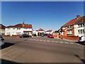
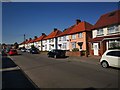
2
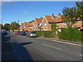
Kingsway, Hayes
The view along Kingsway, a residential road in Hayes.
Image: © Alan Hunt
Taken: 6 Oct 2012
0.12 miles
3
Hayes End Park
The park and sports ground alongside the A4020.
Image: © Alan Hunt
Taken: 6 Oct 2012
0.16 miles
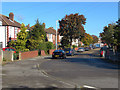
4
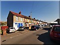
Cromwell Road
Named after Oliver Cromwell.
https://en.wikipedia.org/wiki/Oliver_Cromwell
Image: © James Emmans
Taken: 25 Jul 2019
0.17 miles
5
Commonwealth Avenue
Junction with Cromwell Road
Image: © James Emmans
Taken: 25 Jul 2019
0.17 miles
6
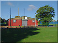
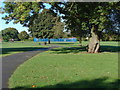
Hayes End Park
Hayes End community centre in Hayes End recreation ground.
Image: © Alan Hunt
Taken: 6 Oct 2012
0.18 miles
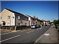
7
North Road Junction with Cromwell Road
Image: © James Emmans
Taken: 25 Jul 2019
0.21 miles
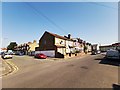
8
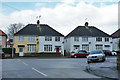
Morgan's Lane, Hayes
Morgan's Lane looking towards the junction with the A4020, The Uxbridge Road.
Image: © Alan Hunt
Taken: 6 Oct 2012
0.21 miles
10
Wood Green Road Junction with Cromwell Road
Image: © James Emmans
Taken: 25 Jul 2019
0.23 miles