IMAGES TAKEN NEAR TO
Wood End Green Road, HAYES, UB3 2SL
Introduction
This page details the photographs taken nearby to Wood End Green Road, UB3 2SL by members of the Geograph project.
The Geograph project started in 2005 with the aim of publishing, organising and preserving representative images for every square kilometre of Great Britain, Ireland and the Isle of Man.

There are currently over 7.5m images from over14,400 individuals and you can help contribute to the project by visiting https://www.geograph.org.uk
Image Map
Images are licensed for reuse under creativecommons.org/licenses/by-sa/2.0
Notes
- Clicking on the map will re-center to the selected point.
- The higher the marker number, the further away the image location is from the centre of the postcode.
Image Listing (19 Images Found)
Images are licensed for reuse under creativecommons.org/licenses/by-sa/2.0
Image
Details
Distance
2
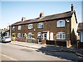
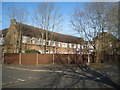
Early Terrace Council Housing
Dated 1913 from the Urban District Council.
Info on Urban District Council : https://en.wikipedia.org/wiki/Urban_district_(Great_Britain_and_Ireland)
Image: © James Emmans
Taken: 25 Jul 2019
0.19 miles
3
Bungalows in Lilac Gardens
Small Cul-de-Sac modern open plan development.
Image: © James Emmans
Taken: 25 Jul 2019
0.19 miles
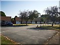
4
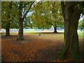
Play area and autumn trees in Barra Hall Park
Image: © Shazz
Taken: 12 Sep 2013
0.19 miles
5
Hayes: The former Hayes Cottage Hospital
The hospital with just 5 beds was opened in 1898 on Grange Road. By 1948, when the hospital became part of the NHS, its capacity had expanded to 22 beds. In 1990 the hospital closed and became a private nursing home.
Image: © Nigel Cox
Taken: 11 Jan 2015
0.20 miles
6
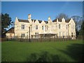
Hayes: Barra Hall
Barra Hall is a Grade II Listed building described on the English Heritage website thus:-
"Mid-late C19 building in a sort of Jacobean style with Scottish baronial touches. 2 storeys, irregular. North (entrance) front of 4 bays, the left a chimney bay. Stucco with tiled roofs. Varied skyline of plain and shaped gables with ball finials. Mullioned and transomed casements, some in projecting square or canted bays. Continuous hoodmoulds over 1st floor windows. Projecting porch with battlemented parapet. Similar long south-west front of L-shape, with round projecting turrets at outer angles."
This is the view of the south-east facing side which the photographer thinks that English Heritage mean by the "south-west front".
On the earliest available online Ordnance Survey map, surveyed around 1865, the building is shown as Grove Lodge, but in 1923 it was purchased by the then Hayes Urban District Council as their Town Hall, continuing in this function until the 1960s.
Image: © Nigel Cox
Taken: 11 Jan 2015
0.20 miles
8
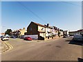
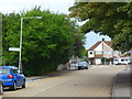
North Road Junction with Cromwell Road
Image: © James Emmans
Taken: 25 Jul 2019
0.22 miles
9
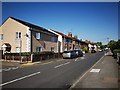
Wood Green Road Junction with Cromwell Road
Image: © James Emmans
Taken: 25 Jul 2019
0.22 miles