IMAGES TAKEN NEAR TO
Evergreen Way, HAYES, UB3 2BH
Introduction
This page details the photographs taken nearby to Evergreen Way, UB3 2BH by members of the Geograph project.
The Geograph project started in 2005 with the aim of publishing, organising and preserving representative images for every square kilometre of Great Britain, Ireland and the Isle of Man.

There are currently over 7.5m images from over14,400 individuals and you can help contribute to the project by visiting https://www.geograph.org.uk
Image Map
Images are licensed for reuse under creativecommons.org/licenses/by-sa/2.0
Notes
- Clicking on the map will re-center to the selected point.
- The higher the marker number, the further away the image location is from the centre of the postcode.
Image Listing (19 Images Found)
Images are licensed for reuse under creativecommons.org/licenses/by-sa/2.0
Image
Details
Distance
1
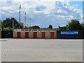
Floodlights of Hayes and Yeading United FC
For details of the club see Image
Image: © David Hawgood
Taken: 5 Aug 2010
0.08 miles
2
Hayes and Yeading United Football Club
[Description in 2010] View across car park from Church Road. For information about the club and its components Hayes FC and Yeading FC which merged in May 2007, see club website https://www.hyufc.com/. The club plays in the Blue Square Premier league of the Football Conference. The merged club started in Conference South, and won promotion to Blue Square Premier in 2008/9. Hayes FC (the missioners) was founded in 1909 as Botwell Mission. Yeading FC (the Ding) started in 1960 as Yeading Youth Club. Both clubs had notable successes in FA and FA amateur cups, as well as many in lower leagues and Middlesex events.
[edit August 2022] Wikipedia article says "It currently competes in the Southern League Premier Division South and plays its home matches at the Skyex stadium." There have been several changes of ground, some temporary.
Image: © David Hawgood
Taken: 5 Aug 2010
0.11 miles
3
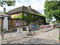
Hayes and Yeading United - club house
This is directly on Church Road, next to the big carpark which is in front of the ground. For information about the club and its components Hayes FC and Yeading FC which merged in May 2007, see club website http://www.hyufc.net/ .
Image: © David Hawgood
Taken: 5 Aug 2010
0.14 miles
4
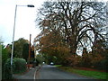
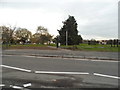
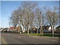
Freemans Lane, Hayes
Barra Hall Park on right. Looking west.
Image: © Ray Stanton
Taken: 11 Nov 2005
0.16 miles
7
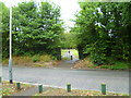
Looking into Barra Hall Park from Freemans Lane
Image: © Shazz
Taken: 12 Sep 2013
0.18 miles
8
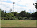
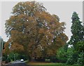
Barra Hall Park
Barra Hall Park consists of Barra Hall, once a manor house, and its associated grounds. The site was bought by the then Hayes Urban District Council in 1923. The main building was the Town Hall until the 1960s. The park, with its Edwardian design, includes an open air theatre and a bandstand.
Image: © Marathon
Taken: 6 Jun 2018
0.18 miles
9
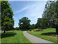
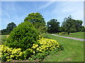
Path in Barra Hall Park
Barra Hall Park consists of Barra Hall, once a manor house, and its associated grounds. The site was bought by the then Hayes Urban District Council in 1923. The main building was the Town Hall until the 1960s. The park, with its Edwardian design, includes an open air theatre and a bandstand.
Image: © Marathon
Taken: 6 Jun 2018
0.18 miles
10
Hayes: Townfield Road Bus Stop
This bus stop is on Church Road and is served by the 195, H98 and U7 buses.
Image: © Nigel Cox
Taken: 11 Jan 2015
0.19 miles