IMAGES TAKEN NEAR TO
Seaton Road, HAYES, UB3 1NT
Introduction
This page details the photographs taken nearby to Seaton Road, UB3 1NT by members of the Geograph project.
The Geograph project started in 2005 with the aim of publishing, organising and preserving representative images for every square kilometre of Great Britain, Ireland and the Isle of Man.

There are currently over 7.5m images from over14,400 individuals and you can help contribute to the project by visiting https://www.geograph.org.uk
Image Map
Images are licensed for reuse under creativecommons.org/licenses/by-sa/2.0
Notes
- Clicking on the map will re-center to the selected point.
- The higher the marker number, the further away the image location is from the centre of the postcode.
Image Listing (7 Images Found)
Images are licensed for reuse under creativecommons.org/licenses/by-sa/2.0
Image
Details
Distance
1
Ross Close, Harlington
Looking from Mildred Avenue.
Image: © Robin Webster
Taken: 22 Apr 2018
0.09 miles
2
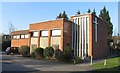
Christ Church, Waltham Avenue, Harlington
Image: © John Salmon
Taken: 28 Jan 2006
0.15 miles
3
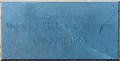
Christ Church, Waltham Avenue, Harlington - Foundation stone
Image: © John Salmon
Taken: 28 Jan 2006
0.15 miles
4
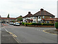
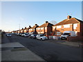
Houses at corner of Mildred Avenue and Waltham Avenue, Hayes
Image: © Robin Webster
Taken: 22 Apr 2018
0.15 miles
5
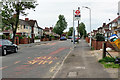
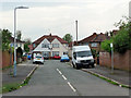
Elers Road bus stop
On Mildred Avenue, it is served by regular bus route U4 towards Prologis Park. Oddly the stop for the other direction, seen across the road, is called Ross Close.
Image: © Robin Webster
Taken: 22 Apr 2018
0.15 miles
6
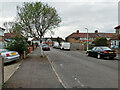
Pinkwell Avenue, Hayes
Westwards towards Mildred Avenue.
Image: © Robin Webster
Taken: 22 Apr 2018
0.17 miles