IMAGES TAKEN NEAR TO
Wentworth Road, SOUTHALL, UB2 5TU
Introduction
This page details the photographs taken nearby to Wentworth Road, UB2 5TU by members of the Geograph project.
The Geograph project started in 2005 with the aim of publishing, organising and preserving representative images for every square kilometre of Great Britain, Ireland and the Isle of Man.

There are currently over 7.5m images from over14,400 individuals and you can help contribute to the project by visiting https://www.geograph.org.uk
Image Map
Images are licensed for reuse under creativecommons.org/licenses/by-sa/2.0
Notes
- Clicking on the map will re-center to the selected point.
- The higher the marker number, the further away the image location is from the centre of the postcode.
Image Listing (69 Images Found)
Images are licensed for reuse under creativecommons.org/licenses/by-sa/2.0
Image
Details
Distance

6
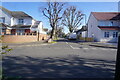
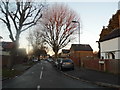
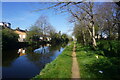
Orange Way after Wiltshire (537)
A road called The Common is beside the towpath here and this shows the junction with Manor Way.
Image: © Shazz
Taken: 12 Sep 2013
0.06 miles

8
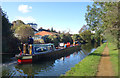
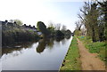
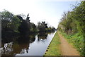
Fuel Sales on the Canal
A mobile diesel and gas service for boats on the Grand Union Canal.
Image: © Des Blenkinsopp
Taken: 19 Oct 2019
0.06 miles