IMAGES TAKEN NEAR TO
Ringway, SOUTHALL, UB2 5SS
Introduction
This page details the photographs taken nearby to Ringway, UB2 5SS by members of the Geograph project.
The Geograph project started in 2005 with the aim of publishing, organising and preserving representative images for every square kilometre of Great Britain, Ireland and the Isle of Man.

There are currently over 7.5m images from over14,400 individuals and you can help contribute to the project by visiting https://www.geograph.org.uk
Image Map
Images are licensed for reuse under creativecommons.org/licenses/by-sa/2.0
Notes
- Clicking on the map will re-center to the selected point.
- The higher the marker number, the further away the image location is from the centre of the postcode.
Image Listing (39 Images Found)
Images are licensed for reuse under creativecommons.org/licenses/by-sa/2.0
Image
Details
Distance
1
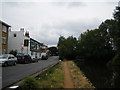
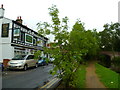
"The Common" & Grand Union Canal
The road is named "The Common" as Southall Recreation Ground borders to the left. The pub on the left is The Old Oak Tree.
Image: © Ray Stanton
Taken: 13 Jul 2006
0.16 miles
2
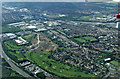
Heston from the air
Airlinks golf course is on part of the site of the former Heston Aerodrome http://www.transportheritage.com/find-heritage-locations.html?sobi2Task=sobi2Details&sobi2Id=274 & http://en.wikipedia.org/wiki/Heston_Aerodrome .
Image: © Thomas Nugent
Taken: 19 May 2014
0.19 miles
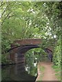
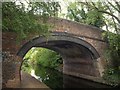
3
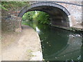
Bridge 202, Grand Union Canal
Not too many of the original style bridges left in this area. This one carries North Hyde Lane.
Image: © Robin Webster
Taken: 16 Sep 2012
0.19 miles
4
Grand Union Canal bridge 202
A view of Image from the other direction, and with leaves on the trees making a very different scene.
Image: © Derek Harper
Taken: 20 Sep 2010
0.19 miles
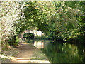
5
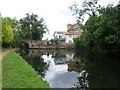
Grand Union Canal passes under North Hyde Lane
The section of the Grand Union Canal through Hanwell Locks and Norwood from the River Thames at Brentford was opened in 1794. It was the first section of what was originally called the Grand Junction Canal. Its purpose was to provide a new, shorter and quicker transport route between London and Birmingham by connecting with a network of canals at Braunston near Daventry. When the canal reached Braunston in 1805 it cut 60 miles off the shortest alternative route.
This view is from the towpath alongside The Common looking towards the old bridge which takes North Hyde Lane over the canal. For a view on the bridge see http://www.geograph.org.uk/photo/4188383
Image: © Marathon
Taken: 1 Oct 2014
0.19 miles
6
Orange Way after Wiltshire (539)
The path passes "The Old Oak Tree" PH before reaching the bridge at North Hyde Lane.
Image: © Shazz
Taken: 12 Sep 2013
0.20 miles
7
Grand Union Canal at North Hyde Lane
The section of the Grand Union Canal through Hanwell Locks and Norwood from the River Thames at Brentford was opened in 1794. It was the first section of what was originally called the Grand Junction Canal. Its purpose was to provide a new, shorter and quicker transport route between London and Birmingham by connecting with a network of canals at Braunston near Daventry. When the canal reached Braunston in 1805 it cut 60 miles off the shortest alternative route.
This view is from the towpath alongside The Common looking towards the old bridge which takes North Hyde Lane over the canal. For a view on the bridge see http://www.geograph.org.uk/photo/4188383
Image: © Marathon
Taken: 1 Oct 2014
0.20 miles
9
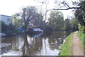
Grand Union Canal bridge 202
A closer view of Image, showing the brickwork. The bridge is locally listed by Ealing Council.
Image: © Derek Harper
Taken: 20 Sep 2010
0.20 miles
