IMAGES TAKEN NEAR TO
Craneswater Park, SOUTHALL, UB2 5RR
Introduction
This page details the photographs taken nearby to Craneswater Park, UB2 5RR by members of the Geograph project.
The Geograph project started in 2005 with the aim of publishing, organising and preserving representative images for every square kilometre of Great Britain, Ireland and the Isle of Man.

There are currently over 7.5m images from over14,400 individuals and you can help contribute to the project by visiting https://www.geograph.org.uk
Image Map
Images are licensed for reuse under creativecommons.org/licenses/by-sa/2.0
Notes
- Clicking on the map will re-center to the selected point.
- The higher the marker number, the further away the image location is from the centre of the postcode.
Image Listing (23 Images Found)
Images are licensed for reuse under creativecommons.org/licenses/by-sa/2.0
Image
Details
Distance
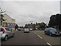
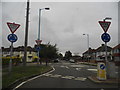
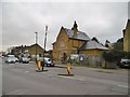
1
Thorncliffe Road at the junction of Craneswater
Image: © David Howard
Taken: 17 Aug 2013
0.03 miles
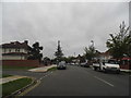
2
Thorncliffe Road. North Hyde
You couldn't get a more typical road in Middlesex if you tried. Much was made after the underground railway opened it up, and the houses were built along with huge industrial estates. Before then the part beyond London was just towns with fields in between them, that has now all been filled in with these sort of houses.
Image: © David Howard
Taken: 7 Dec 2014
0.08 miles
3
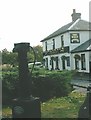
The Wolf Inn at Norwood Green
The old public water pump is in the foreground.
Image: © Ian Day
Taken: Unknown
0.11 miles
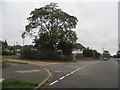
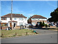
4
Mini roundabouts on Thorncliffe Road, North Hyde
I didn't even know North Hyde existed till today and I only live just across London.
Image: © David Howard
Taken: 17 Aug 2013
0.12 miles
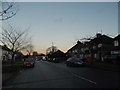
7
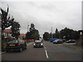
Norwood Road, Southall
The white pole on the corner is a mobile phone aerial
Image: © David Howard
Taken: 17 Aug 2013
0.18 miles
8
Norwood Green, former police station
On Norwood Road; now residential, though notice boards still remain.
Image: © Mike Faherty
Taken: 12 Feb 2016
0.19 miles
9
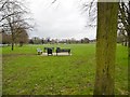
Norwood Green
A triangular open space at the heart of the village.
Image: © Mike Faherty
Taken: 12 Feb 2016
0.20 miles