IMAGES TAKEN NEAR TO
Clarence Street, SOUTHALL, UB2 5BJ
Introduction
This page details the photographs taken nearby to Clarence Street, UB2 5BJ by members of the Geograph project.
The Geograph project started in 2005 with the aim of publishing, organising and preserving representative images for every square kilometre of Great Britain, Ireland and the Isle of Man.

There are currently over 7.5m images from over14,400 individuals and you can help contribute to the project by visiting https://www.geograph.org.uk
Image Map
Images are licensed for reuse under creativecommons.org/licenses/by-sa/2.0
Notes
- Clicking on the map will re-center to the selected point.
- The higher the marker number, the further away the image location is from the centre of the postcode.
Image Listing (146 Images Found)
Images are licensed for reuse under creativecommons.org/licenses/by-sa/2.0
Image
Details
Distance

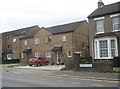
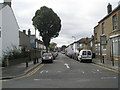
2
Looking from Clarence Street into Sussex Road
Image: © Basher Eyre
Taken: 3 Oct 2009
0.04 miles
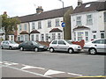
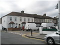
3
Et tu Queen's Head!
My first school has been knocked down and flats built on the site of the pub where he used to retire to after work. Taken in Dudley Road.
Image: © Basher Eyre
Taken: 3 Oct 2009
0.04 miles
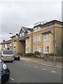
4
Looking from Dudley Road into Queens Road
Image: © Basher Eyre
Taken: 3 Oct 2009
0.05 miles
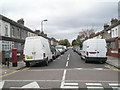
5
Looking from Dudley Road down Sussex Road
Image: © Basher Eyre
Taken: 3 Oct 2009
0.05 miles
7
Approaching the junction of Sussex Road and Dudley Road
Image: © Basher Eyre
Taken: 3 Oct 2009
0.05 miles
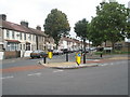
8
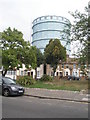
Small public open space at the junction of Queens and Dudley Roads
Image: © Basher Eyre
Taken: 3 Oct 2009
0.05 miles
9

Looking northwards up Sussex Road towards Dudley Road
Image: © Basher Eyre
Taken: 3 Oct 2009
0.06 miles