IMAGES TAKEN NEAR TO
Tentelow Lane, SOUTHALL, UB2 4LE
Introduction
This page details the photographs taken nearby to Tentelow Lane, UB2 4LE by members of the Geograph project.
The Geograph project started in 2005 with the aim of publishing, organising and preserving representative images for every square kilometre of Great Britain, Ireland and the Isle of Man.

There are currently over 7.5m images from over14,400 individuals and you can help contribute to the project by visiting https://www.geograph.org.uk
Image Map
Images are licensed for reuse under creativecommons.org/licenses/by-sa/2.0
Notes
- Clicking on the map will re-center to the selected point.
- The higher the marker number, the further away the image location is from the centre of the postcode.
Image Listing (50 Images Found)
Images are licensed for reuse under creativecommons.org/licenses/by-sa/2.0
Image
Details
Distance

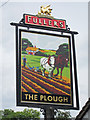
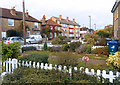
3

Norwood Green, Plough
Historic pub on Tentelow Lane; dating from C17, with wooden beams and an open fire. Cask ales on offer at my visit: Fuller's London Pride, Gale Seafarers, Portobello Chestnut. The building is listed by Historic England, and also by the Good Beer Guide: http://www.imagesofengland.org.uk/Details/Default.aspx?id=201047&mode=adv
Image: © Mike Faherty
Taken: 12 Feb 2016
0.01 miles
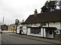
8
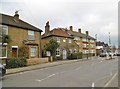
Norwood Green, former free school
On Tentelow Lane; dating from C18, bearing a plaque "Erected by EB 1767". The building is listed by Historic England (Grade II*): http://www.imagesofengland.org.uk/Details/Default.aspx?id=201046&mode=adv
Image: © Mike Faherty
Taken: 12 Feb 2016
0.03 miles
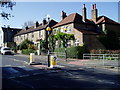
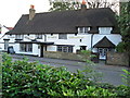
10
Norwood Churchyard
The village of Norwood Green grew around the church of St Mary the Virgin, parts of which date from the 12th century. This is the view along the south side of the church looking towards The Plough in Tentelow Lane.
Image: © Marathon
Taken: 7 Aug 2014
0.04 miles