IMAGES TAKEN NEAR TO
Stour Avenue, SOUTHALL, UB2 4HL
Introduction
This page details the photographs taken nearby to Stour Avenue, UB2 4HL by members of the Geograph project.
The Geograph project started in 2005 with the aim of publishing, organising and preserving representative images for every square kilometre of Great Britain, Ireland and the Isle of Man.

There are currently over 7.5m images from over14,400 individuals and you can help contribute to the project by visiting https://www.geograph.org.uk
Image Map
Images are licensed for reuse under creativecommons.org/licenses/by-sa/2.0
Notes
- Clicking on the map will re-center to the selected point.
- The higher the marker number, the further away the image location is from the centre of the postcode.
Image Listing (95 Images Found)
Images are licensed for reuse under creativecommons.org/licenses/by-sa/2.0
Image
Details
Distance
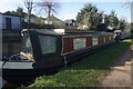
3
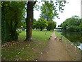
Orange Way after Wiltshire (549)
Geese have gathered on this piece of open ground. A footbridge can be seen ahead.
Image: © Shazz
Taken: 12 Sep 2013
0.08 miles
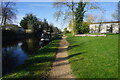
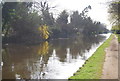
5

View of a footbridge, railings, trees and hut reflected in the Grand Union Canal at Southall
Looking south-southeast.
Image: © Robert Lamb
Taken: 23 Feb 2019
0.08 miles
6
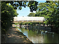
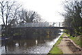
Bridge 203a, Grand Union Canal
A footbridge only for access to Three Bridges Primary School on the right bank.
Image: © Robin Webster
Taken: 16 Sep 2012
0.08 miles