IMAGES TAKEN NEAR TO
Wimborne Avenue, SOUTHALL, UB2 4HB
Introduction
This page details the photographs taken nearby to Wimborne Avenue, UB2 4HB by members of the Geograph project.
The Geograph project started in 2005 with the aim of publishing, organising and preserving representative images for every square kilometre of Great Britain, Ireland and the Isle of Man.

There are currently over 7.5m images from over14,400 individuals and you can help contribute to the project by visiting https://www.geograph.org.uk
Image Map
Images are licensed for reuse under creativecommons.org/licenses/by-sa/2.0
Notes
- Clicking on the map will re-center to the selected point.
- The higher the marker number, the further away the image location is from the centre of the postcode.
Image Listing (94 Images Found)
Images are licensed for reuse under creativecommons.org/licenses/by-sa/2.0
Image
Details
Distance
1
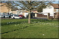
View of a patch of crocuses around a tree on Frogmore Green
Looking north-northeast.
Image: © Robert Lamb
Taken: 23 Feb 2019
0.05 miles
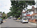
2
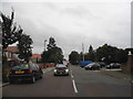
Norwood Road, Southall
The white pole on the corner is a mobile phone aerial
Image: © David Howard
Taken: 17 Aug 2013
0.06 miles
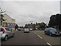
3
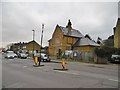
Norwood Green, former police station
On Norwood Road; now residential, though notice boards still remain.
Image: © Mike Faherty
Taken: 12 Feb 2016
0.08 miles
6
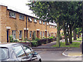
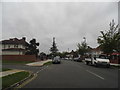
Terraced houses on Blanford Road
Image: © Oast House Archive
Taken: 14 Jul 2011
0.10 miles
9
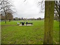
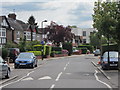
Norwood Green
A triangular open space at the heart of the village.
Image: © Mike Faherty
Taken: 12 Feb 2016
0.12 miles
10
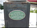
Plaque on water pump next to the Wolf public house
Image: © J Taylor
Taken: 4 Feb 2009
0.12 miles