IMAGES TAKEN NEAR TO
Longford Avenue, SOUTHALL, UB1 3QN
Introduction
This page details the photographs taken nearby to Longford Avenue, UB1 3QN by members of the Geograph project.
The Geograph project started in 2005 with the aim of publishing, organising and preserving representative images for every square kilometre of Great Britain, Ireland and the Isle of Man.

There are currently over 7.5m images from over14,400 individuals and you can help contribute to the project by visiting https://www.geograph.org.uk
Image Map
Images are licensed for reuse under creativecommons.org/licenses/by-sa/2.0
Notes
- Clicking on the map will re-center to the selected point.
- The higher the marker number, the further away the image location is from the centre of the postcode.
Image Listing (43 Images Found)
Images are licensed for reuse under creativecommons.org/licenses/by-sa/2.0
Image
Details
Distance
1

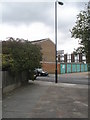
Footpath into Brent River Park at Dormers Wells
This narrow path by Dormers Wells Infants School leads into a large open area which includes West Middlesex golf course.
Image: © David Hawgood
Taken: 10 Jun 2005
0.05 miles
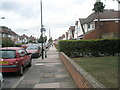
3

Allotment Gardens, Dormers Wells Lane, Southall
Image: © MrC
Taken: 19 Apr 2010
0.10 miles

6
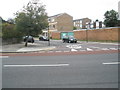
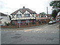
Junction of Longford Avenue and the Uxbridge Road
Image: © Basher Eyre
Taken: 3 Oct 2009
0.13 miles
7
Junction of Stamford Close and Oakwood Avenue
Image: © Basher Eyre
Taken: 3 Oct 2009
0.14 miles
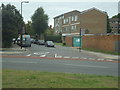
9

Junction of Milford Road and the Uxbridge Road
Image: © Basher Eyre
Taken: 3 Oct 2009
0.14 miles