IMAGES TAKEN NEAR TO
Haldane Road, SOUTHALL, UB1 3NT
Introduction
This page details the photographs taken nearby to Haldane Road, UB1 3NT by members of the Geograph project.
The Geograph project started in 2005 with the aim of publishing, organising and preserving representative images for every square kilometre of Great Britain, Ireland and the Isle of Man.

There are currently over 7.5m images from over14,400 individuals and you can help contribute to the project by visiting https://www.geograph.org.uk
Image Map
Images are licensed for reuse under creativecommons.org/licenses/by-sa/2.0
Notes
- Clicking on the map will re-center to the selected point.
- The higher the marker number, the further away the image location is from the centre of the postcode.
Image Listing (76 Images Found)
Images are licensed for reuse under creativecommons.org/licenses/by-sa/2.0
Image
Details
Distance
1
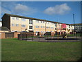
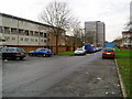
Southall: Golf Links Estate: Verulam Court
Verulam Court is one of four near identical three-storey housing blocks on this London Borough of Ealing estate, the others being Ashridge, Birkdale and Peebles. The estate was not the first housing development on this site, as the 1962 Ordnance Survey map shows a completely different layout of neat rows of identical houses, probably post-war prefabs.
Image: © Nigel Cox
Taken: 18 Aug 2013
0.04 miles
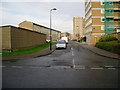
2
Haldane Road, golf Links Estate, looking west
Sheringham Tower is in the background.
Image: © J Taylor
Taken: 8 Dec 2008
0.05 miles
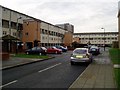
3
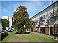
Southall - Redcroft Road
Tower block and flats in a densely populated neighbourhood of Southall.
Image: © James Emmans
Taken: 18 Jan 2017
0.07 miles
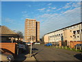
4

Ashridge Court, Haldane Road, Golf Links Estate
At the junction with Redcroft Road.
Image: © J Taylor
Taken: 8 Dec 2008
0.07 miles
5
Baird Avenue, Golf Links Estate
Sheringham Tower is in the background.
Image: © J Taylor
Taken: 8 Dec 2008
0.07 miles
6

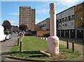
Golf Links Estate
Redcroft Road seen from the junction with Haldane Road. On the left is Ashridge Court whilst on the right is Farnham Court. in the distance is Gleneagles Tower.
Image: © Martin Addison
Taken: 4 Oct 2013
0.07 miles
7
Southall: Golf Links Estate: Baird Avenue
This was taken looking along the north side of Baird Avenue with the 13 storey Sheringham Tower in the distance. It is one of three near-identical tower blocks on this London Borough of Ealing estate, the others being Gleneagles and St Andrews. The estate was not the first housing development on this site, as the 1962 Ordnance Survey map shows a completely different layout of neat rows of identical houses, probably post-war prefabs. Baird Avenue did however exist at that time. The tree is a rowan.
Image: © Nigel Cox
Taken: 18 Aug 2013
0.08 miles
8
Southall: Golf Links Estate: Redcroft Road
The giant pink vent pipe appears to have suddenly risen from the ground, knocking the puny little concrete bollard over in the process... Whatever, this is Redcroft Road with Gleneagles Tower in the distance, all on the London Borough of Ealing's Golf Links Estate.
Image: © Nigel Cox
Taken: 18 Aug 2013
0.08 miles
9
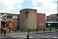
Emmanuel Church, Fleming Road, Southall Green
Image: © John Salmon
Taken: 16 May 2012
0.08 miles