IMAGES TAKEN NEAR TO
Lovell Road, SOUTHALL, UB1 3LD
Introduction
This page details the photographs taken nearby to Lovell Road, UB1 3LD by members of the Geograph project.
The Geograph project started in 2005 with the aim of publishing, organising and preserving representative images for every square kilometre of Great Britain, Ireland and the Isle of Man.

There are currently over 7.5m images from over14,400 individuals and you can help contribute to the project by visiting https://www.geograph.org.uk
Image Map
Images are licensed for reuse under creativecommons.org/licenses/by-sa/2.0
Notes
- Clicking on the map will re-center to the selected point.
- The higher the marker number, the further away the image location is from the centre of the postcode.
Image Listing (17 Images Found)
Images are licensed for reuse under creativecommons.org/licenses/by-sa/2.0
Image
Details
Distance
1
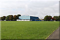
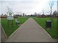
Mount Pleasant Leisure Gardens
Seen from the entrance on Wallis Road, looking towards Dormers Wells Sports and Leisure Centre.
Image: © Martin Addison
Taken: 4 Oct 2013
0.11 miles
2
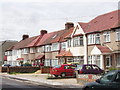
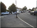
Houses on Allenby Road, Dormer's Wells
Image: © David Hawgood
Taken: 1 Jul 2005
0.12 miles
3
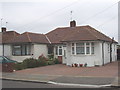
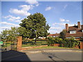
Bungalow on Allenby Road, Dormer's Wells
This is one of a row of similar houses near Allenby Infant School. There are not many single-storey houses in this area.
Image: © David Hawgood
Taken: 10 Jun 2005
0.13 miles
4
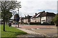
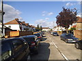
Telford Road
Seen from the corner of Edison Drive. The road opposite is Wallis Road.
Image: © Martin Addison
Taken: 4 Oct 2013
0.15 miles
6

Former building of Dormers Wells High School
Building demolished in January 2013
The school relocated to a new building in Allenby Road in 2012
Image: © MrC
Taken: 7 Apr 2009
0.22 miles
8
Southall: Jubilee Park
The park was acquired by the then local council in the late 1930s, and was named to commemorate the Silver Jubilee of King George V in 1935. The land was formerly farmland belonging to Sparrow Farm and Waxlow Manor Farm, the latter having been on the route of the present-day Cornwall Avenue.
Image: © Nigel Cox
Taken: 13 Jan 2013
0.22 miles
9
The entrance to Jubilee Park on Jubilee Gardens
Image: © David Howard
Taken: 16 Aug 2014
0.22 miles
10
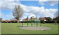
Basketball, Jubilee Park
'In 1935 Ealing Council purchased a site of over 12 acres of former farmland to create Jubilee Park and Jubilee Gardens, named for King George V's Silver Jubilee." London Parks & Gardens Trust.
Image: © Des Blenkinsopp
Taken: 11 Mar 2019
0.23 miles