IMAGES TAKEN NEAR TO
Panhard Place, SOUTHALL, UB1 3JJ
Introduction
This page details the photographs taken nearby to Panhard Place, UB1 3JJ by members of the Geograph project.
The Geograph project started in 2005 with the aim of publishing, organising and preserving representative images for every square kilometre of Great Britain, Ireland and the Isle of Man.

There are currently over 7.5m images from over14,400 individuals and you can help contribute to the project by visiting https://www.geograph.org.uk
Image Map
Images are licensed for reuse under creativecommons.org/licenses/by-sa/2.0
Notes
- Clicking on the map will re-center to the selected point.
- The higher the marker number, the further away the image location is from the centre of the postcode.
Image Listing (42 Images Found)
Images are licensed for reuse under creativecommons.org/licenses/by-sa/2.0
Image
Details
Distance
1
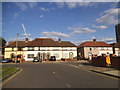
Longridge Lane at the junction of Faraday Road
Image: © David Howard
Taken: 16 Aug 2014
0.04 miles


4
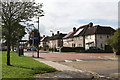
Telford Road
Seen from the corner of Edison Drive. The road opposite is Wallis Road.
Image: © Martin Addison
Taken: 4 Oct 2013
0.12 miles
5
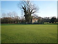
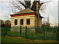
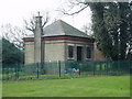
Valve House
This marked-up on late 18th century maps as a valve house.It is located within the grounds of the West Middlesex golf course.
Image: © J Taylor
Taken: 29 Jan 2009
0.14 miles
6
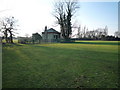
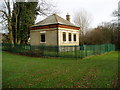
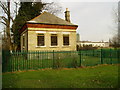
Valve House
This marked-up on late 18th century maps as a valve house. It is located within the grounds of the West Middlesex golf course.
Image: © J Taylor
Taken: 29 Jan 2009
0.14 miles