IMAGES TAKEN NEAR TO
Uxbridge Road, SOUTHALL, UB1 3HH
Introduction
This page details the photographs taken nearby to Uxbridge Road, UB1 3HH by members of the Geograph project.
The Geograph project started in 2005 with the aim of publishing, organising and preserving representative images for every square kilometre of Great Britain, Ireland and the Isle of Man.

There are currently over 7.5m images from over14,400 individuals and you can help contribute to the project by visiting https://www.geograph.org.uk
Image Map
Images are licensed for reuse under creativecommons.org/licenses/by-sa/2.0
Notes
- Clicking on the map will re-center to the selected point.
- The higher the marker number, the further away the image location is from the centre of the postcode.
Image Listing (160 Images Found)
Images are licensed for reuse under creativecommons.org/licenses/by-sa/2.0
Image
Details
Distance
1
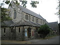
Holy Trinity, Southall in the Uxbridge Road
Image: © Basher Eyre
Taken: 3 Oct 2009
0.01 miles


6
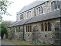
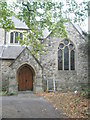
Southall: Holy Trinity Church
The church was originally built as a district church in 1881 within the civil parish boundaries of Hayes St Mary. It was rebuilt in brick in 1891. It stands on the north side of the A4020 Uxbridge Road.
Image: © Nigel Cox
Taken: 13 Jan 2013
0.03 miles


