IMAGES TAKEN NEAR TO
Uxbridge Road, SOUTHALL, UB1 3DX
Introduction
This page details the photographs taken nearby to Uxbridge Road, UB1 3DX by members of the Geograph project.
The Geograph project started in 2005 with the aim of publishing, organising and preserving representative images for every square kilometre of Great Britain, Ireland and the Isle of Man.

There are currently over 7.5m images from over14,400 individuals and you can help contribute to the project by visiting https://www.geograph.org.uk
Image Map
Images are licensed for reuse under creativecommons.org/licenses/by-sa/2.0
Notes
- Clicking on the map will re-center to the selected point.
- The higher the marker number, the further away the image location is from the centre of the postcode.
Image Listing (100 Images Found)
Images are licensed for reuse under creativecommons.org/licenses/by-sa/2.0
Image
Details
Distance
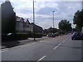
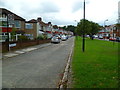
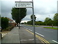
2
Morland Gardens at junction with the Uxbridge Road.
Image: © J Taylor
Taken: 8 Dec 2008
0.05 miles
4
Entrance to footpath leading through the West Middlesex golf course to Greenford Road
Image: © J Taylor
Taken: 1 Dec 2008
0.06 miles
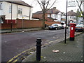
6
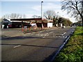
Texaco petrol station
Uxbridge road looking eastwards towards the Iron Bridge.
Image: © J Taylor
Taken: 1 Dec 2008
0.07 miles
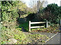
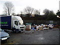
7

Foot path from the Uxbridge Road leading to the West Middlesex golf course
The wall on the right is the perimeter of the Texaco petrol station and the Iron Bridge Motor Company premises.
Image: © J Taylor
Taken: 1 Dec 2008
0.08 miles
9
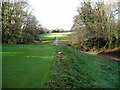
Footpath across the West Middlesex golf course
Looking towards the Uxbridge Road.
Image: © J Taylor
Taken: 1 Dec 2008
0.09 miles
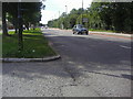
10
Looking west on Uxbridge Road from Lyndhurst Avenue
Image: © Shazz
Taken: 12 Sep 2013
0.10 miles