IMAGES TAKEN NEAR TO
Rutland Road, SOUTHALL, UB1 2UR
Introduction
This page details the photographs taken nearby to Rutland Road, UB1 2UR by members of the Geograph project.
The Geograph project started in 2005 with the aim of publishing, organising and preserving representative images for every square kilometre of Great Britain, Ireland and the Isle of Man.

There are currently over 7.5m images from over14,400 individuals and you can help contribute to the project by visiting https://www.geograph.org.uk
Image Map
Images are licensed for reuse under creativecommons.org/licenses/by-sa/2.0
Notes
- Clicking on the map will re-center to the selected point.
- The higher the marker number, the further away the image location is from the centre of the postcode.
Image Listing (29 Images Found)
Images are licensed for reuse under creativecommons.org/licenses/by-sa/2.0
Image
Details
Distance
1
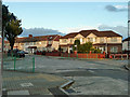
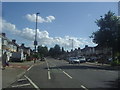
Evening at the crossroads
Ascot Gardens and Cornwall Avenue intersect.
Image: © Robin Webster
Taken: 13 Oct 2012
0.14 miles

3
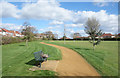
Jubilee Park, Southall
"In 1935 Ealing Council purchased a site of over 12 acres of former farmland to create Jubilee Park and Jubilee Gardens, named for King George V's Silver Jubilee"
Info from London Parks & Gardens Trust. http://www.londongardensonline.org.uk/gardens-online-record.php?ID=EAL028
Image: © Des Blenkinsopp
Taken: 11 Mar 2019
0.16 miles
5
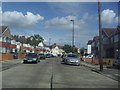
Cornwall Avenue, Southall
Roads seamed with tarmac have tended to be found in the most distant suburbs and become increasingly rare in the 2000s, these are a good example, while others had yellower surfaces made in the same way with slabs being fixed together along the edges like a flat roof.
Image: © David Howard
Taken: 3 Aug 2012
0.18 miles
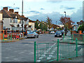
7
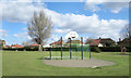
Basketball, Jubilee Park
'In 1935 Ealing Council purchased a site of over 12 acres of former farmland to create Jubilee Park and Jubilee Gardens, named for King George V's Silver Jubilee." London Parks & Gardens Trust.
Image: © Des Blenkinsopp
Taken: 11 Mar 2019
0.20 miles
8
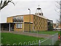
Southall: Christ the Redeemer
The church is on the west side of Allenby Road, formerly Muddy Lane, and was built in 1964 to the designs of Michael Farey. Prior to the church being built the site was in use as allotment gardens.
Image: © Nigel Cox
Taken: 13 Jan 2013
0.20 miles
9

Christ the Redeemer, Allenby Road, Southall - Statue
Madonna & Child
Image: © John Salmon
Taken: 6 Oct 2004
0.20 miles
10

Christ the Redeemer, Allenby Road, Southall - Roof
Image: © John Salmon
Taken: 6 Oct 2004
0.20 miles