IMAGES TAKEN NEAR TO
Cherry Avenue, SOUTHALL, UB1 1DF
Introduction
This page details the photographs taken nearby to Cherry Avenue, UB1 1DF by members of the Geograph project.
The Geograph project started in 2005 with the aim of publishing, organising and preserving representative images for every square kilometre of Great Britain, Ireland and the Isle of Man.

There are currently over 7.5m images from over14,400 individuals and you can help contribute to the project by visiting https://www.geograph.org.uk
Image Map
Images are licensed for reuse under creativecommons.org/licenses/by-sa/2.0
Notes
- Clicking on the map will re-center to the selected point.
- The higher the marker number, the further away the image location is from the centre of the postcode.
Image Listing (120 Images Found)
Images are licensed for reuse under creativecommons.org/licenses/by-sa/2.0
Image
Details
Distance
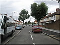
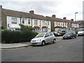
3
Junction of Cherry Avenue and Beaconsfield Road
Image: © Basher Eyre
Taken: 3 Oct 2009
0.05 miles

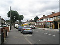
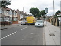
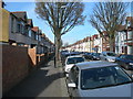
5
Looking from Beaconsfield Road northwards up Ranelagh Road
Image: © Basher Eyre
Taken: 3 Oct 2009
0.06 miles
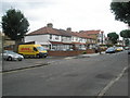
8
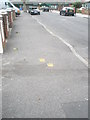
Paw prints on the pavement in Beaconsfield Road
They lead to Blair Peach Primary School.
Image: © Basher Eyre
Taken: 3 Oct 2009
0.07 miles
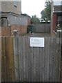
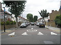
10
Woodlands Road, Southall
A typical side street in this area.
Image: © Danny P Robinson
Taken: 11 Mar 2007
0.07 miles