IMAGES TAKEN NEAR TO
North Way, UXBRIDGE, UB10 9NG
Introduction
This page details the photographs taken nearby to North Way, UB10 9NG by members of the Geograph project.
The Geograph project started in 2005 with the aim of publishing, organising and preserving representative images for every square kilometre of Great Britain, Ireland and the Isle of Man.

There are currently over 7.5m images from over14,400 individuals and you can help contribute to the project by visiting https://www.geograph.org.uk
Image Map
Images are licensed for reuse under creativecommons.org/licenses/by-sa/2.0
Notes
- Clicking on the map will re-center to the selected point.
- The higher the marker number, the further away the image location is from the centre of the postcode.
Image Listing (39 Images Found)
Images are licensed for reuse under creativecommons.org/licenses/by-sa/2.0
Image
Details
Distance

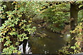
5
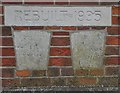
Old Boundary Marker
Bridge Marker consisting of three stones set in the north parapet of a bridge over the River Pinn, Uxbridge. On the left reads BUILT / IN / 1809; the inscription on the right is unreadable; and above both the stone reads REBUILT 1935.
Milestone Society National ID: MX_UXBR01br
Image: © M Bardell
Taken: 2 Jan 2019
0.06 miles
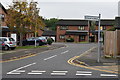

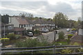
9
Worrall Lane, Uxbridge
A modern housing estate near Hillingdon playing fields and sports complex.
Image: © David Hawgood
Taken: 14 Jun 2020
0.10 miles