IMAGES TAKEN NEAR TO
Long Lane, UXBRIDGE, UB10 8TB
Introduction
This page details the photographs taken nearby to Long Lane, UB10 8TB by members of the Geograph project.
The Geograph project started in 2005 with the aim of publishing, organising and preserving representative images for every square kilometre of Great Britain, Ireland and the Isle of Man.

There are currently over 7.5m images from over14,400 individuals and you can help contribute to the project by visiting https://www.geograph.org.uk
Image Map
Images are licensed for reuse under creativecommons.org/licenses/by-sa/2.0
Notes
- Clicking on the map will re-center to the selected point.
- The higher the marker number, the further away the image location is from the centre of the postcode.
Image Listing (175 Images Found)
Images are licensed for reuse under creativecommons.org/licenses/by-sa/2.0
Image
Details
Distance
1
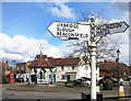
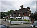
Old Fashioned Signpost, Ickenham
Some of the original buildings of pre suburban Ickenham village, together with the parish church and village pump, make a pleasant grouping around this busy road junction.
The authorities have obviously decided not to spoil the effect with ugly modern signposts.
Image: © Des Blenkinsopp
Taken: 30 Mar 2016
0.01 miles

3

Old Direction Sign - Signpost by the B466, Ickenham, Hillingdon and Ickenham Parish
Nipple finial - 2 arms; Middlesex CC shield by the B466, in parish of Hillingdon and Ickenham (Hillingdon District), Ickenham, junction with B467, Long Lane and Swakeleys Road.
Surveyed
Milestone Society National ID: MX_TQ0786
Image: © Milestone Society
Taken: Unknown
0.02 miles
4
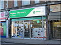
Hopkins Pharmacy, Swakeleys Road
Hooray - an independent chemist's, not another ******* Boots.
Image: © Mike Quinn
Taken: 3 Feb 2016
0.02 miles
6
Water pump
Grade II listed. https://historicengland.org.uk/listing/the-list/list-entry/1358381
Image: © N Chadwick
Taken: 3 Nov 2019
0.02 miles
8

Long Lane junction of Swakeleys Road, Ickenham
Image: © David Howard
Taken: 8 Mar 2011
0.03 miles
10

Ickenham village
Ickenham appears as 'Ticheham' in the Domesday Book of 1086 - see the Wiki entry https://en.wikipedia.org/wiki/Ickenham and http://www.british-history.ac.uk/vch/middx/vol4/pp100-102 . In the foreground (right) is Image; in the middle distance (left) is Image (photographed by David Hawgood).
Image: © Mike Quinn
Taken: 3 Feb 2016
0.03 miles