IMAGES TAKEN NEAR TO
Lawrence Drive, UXBRIDGE, UB10 8RW
Introduction
This page details the photographs taken nearby to Lawrence Drive, UB10 8RW by members of the Geograph project.
The Geograph project started in 2005 with the aim of publishing, organising and preserving representative images for every square kilometre of Great Britain, Ireland and the Isle of Man.

There are currently over 7.5m images from over14,400 individuals and you can help contribute to the project by visiting https://www.geograph.org.uk
Image Map
Images are licensed for reuse under creativecommons.org/licenses/by-sa/2.0
Notes
- Clicking on the map will re-center to the selected point.
- The higher the marker number, the further away the image location is from the centre of the postcode.
Image Listing (78 Images Found)
Images are licensed for reuse under creativecommons.org/licenses/by-sa/2.0
Image
Details
Distance
2
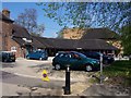
Compass Theatre
The Compass Theatre in Ickenham.
Image: © Ian Harrison
Taken: 11 Apr 2011
0.07 miles

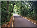
4
Austin's Lane, Ickenham
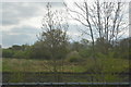
Austin's Lane is followed by the Hillingdon Trail on its way from Long Lane to Ickenham Marsh. Here it has just crossed over the Metropolitan and Piccadilly line, immediately north of Ickenham station.
The Hillingdon Trail is a 20 mile path through Hillingdon's countryside from Cranford in the south-east to Harefield in the north-west. See https://archive.hillingdon.gov.uk/hillingdontrail and http://www.gps-routes.co.uk/routes/home.nsf/RoutesLinksWalks/hillingdon-trail-walking-route for more information.
Image: © Marathon
Taken: 31 Jan 2018
0.07 miles
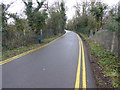
5
Austin's Lane towards Railway Bridge
Paved road part of the Hillingdon Trail
Image: © James Emmans
Taken: 25 Jul 2019
0.08 miles
6
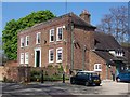
Ickenham Hall
Ickenham Hall, a Grade II listed Georgian mansion. The Compass Theatre was built within the grounds in 1968 and a connecting building between the two was completed in 1976.
Image: © Ian Harrison
Taken: 11 Apr 2011
0.09 miles
7
Ickenham station, 1999
View northward, towards Rayners Lane, Harrow-on-the-Hill: LT Metropolitan & Piccadilly Uxbridge branch. (See also Image).
Image: © Ben Brooksbank
Taken: 1 Aug 1999
0.09 miles
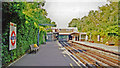
8

Ickenham station, 1999
View southward from the Down platform, towards Uxbridge: London Transport Metropolitan Line (from Baker Street etc. via Harrow-on-the-Hill) and Piccadilly Line (from Cockfosters etc. via Piccadilly Circus, Acton Town and Rayners Lane).
Image: © Ben Brooksbank
Taken: 1 Aug 1999
0.09 miles