IMAGES TAKEN NEAR TO
Long Lane, UXBRIDGE, UB10 8QS
Introduction
This page details the photographs taken nearby to Long Lane, UB10 8QS by members of the Geograph project.
The Geograph project started in 2005 with the aim of publishing, organising and preserving representative images for every square kilometre of Great Britain, Ireland and the Isle of Man.

There are currently over 7.5m images from over14,400 individuals and you can help contribute to the project by visiting https://www.geograph.org.uk
Image Map
Images are licensed for reuse under creativecommons.org/licenses/by-sa/2.0
Notes
- Clicking on the map will re-center to the selected point.
- The higher the marker number, the further away the image location is from the centre of the postcode.
Image Listing (29 Images Found)
Images are licensed for reuse under creativecommons.org/licenses/by-sa/2.0
Image
Details
Distance
1
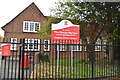
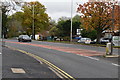
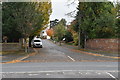
The Douay Martyrs Catholic Secondary School
Image: © N Chadwick
Taken: 3 Nov 2019
0.03 miles
9
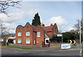
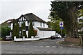
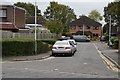
Gabled House, Swakeleys Drive
An unusual property pre dating the standard suburban architecture of much of this area.
Image: © Des Blenkinsopp
Taken: 30 Mar 2016
0.12 miles