IMAGES TAKEN NEAR TO
Sussex Road, UXBRIDGE, UB10 8PN
Introduction
This page details the photographs taken nearby to Sussex Road, UB10 8PN by members of the Geograph project.
The Geograph project started in 2005 with the aim of publishing, organising and preserving representative images for every square kilometre of Great Britain, Ireland and the Isle of Man.

There are currently over 7.5m images from over14,400 individuals and you can help contribute to the project by visiting https://www.geograph.org.uk
Image Map
Images are licensed for reuse under creativecommons.org/licenses/by-sa/2.0
Notes
- Clicking on the map will re-center to the selected point.
- The higher the marker number, the further away the image location is from the centre of the postcode.
Image Listing (7 Images Found)
Images are licensed for reuse under creativecommons.org/licenses/by-sa/2.0
Image
Details
Distance
1
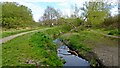
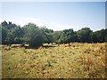
Ickenham Marsh
Ickenham Marsh is an area of grassland and marsh managed as a nature reserve by London Wildlife Trust. Yeading Brook flows through the reserve.
Image: © Mark Percy
Taken: 27 Apr 2021
0.17 miles
2
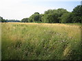
Ickenham
Typical flat open countryside to the east of Ickenham.
Image: © Nigel Cox
Taken: 20 Jul 2006
0.18 miles
4
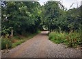
Hillingdon Trail by Ickenham Marsh
This part of the trail runs North from Western Avenue, alongside Yeading Brook and Ickenham Marsh
Image: © David Hawgood
Taken: 14 Jun 2005
0.19 miles
5
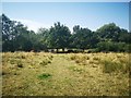
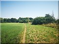
Footpath towards Ruislip Gardens
Fields with pioneer trees encroaching.
Image: © James Emmans
Taken: 25 Jul 2019
0.23 miles
7
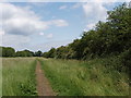
Footpath towards Ickenham Marsh
Passing a long narrow field that had been on fire, possibly lit by the farmer.
Image: © James Emmans
Taken: 25 Jul 2019
0.23 miles