IMAGES TAKEN NEAR TO
High Road, UXBRIDGE, UB10 8LJ
Introduction
This page details the photographs taken nearby to High Road, UB10 8LJ by members of the Geograph project.
The Geograph project started in 2005 with the aim of publishing, organising and preserving representative images for every square kilometre of Great Britain, Ireland and the Isle of Man.

There are currently over 7.5m images from over14,400 individuals and you can help contribute to the project by visiting https://www.geograph.org.uk
Image Map
Images are licensed for reuse under creativecommons.org/licenses/by-sa/2.0
Notes
- Clicking on the map will re-center to the selected point.
- The higher the marker number, the further away the image location is from the centre of the postcode.
Image Listing (179 Images Found)
Images are licensed for reuse under creativecommons.org/licenses/by-sa/2.0
Image
Details
Distance
2
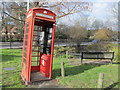
K6 telephone kiosk, High Road (opposite Swakeleys Road), UB10
This poor phone box is both listed https://www.historicengland.org.uk/listing/the-list/list-entry/1080116 and listing (heavily to starboard); it's also sans door. Just beyond is Image
Image: © Mike Quinn
Taken: 2 Mar 2016
0.01 miles
3
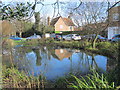
Ickenham village pond
The pond was dug in 1866, at the same time that the village pump was installed - see Image
Image: © Mike Quinn
Taken: 3 Feb 2016
0.02 miles
4

4, High Road, Ickenham
This late 18th C building is Grade II listed http://www.historicengland.org.uk/listing/the-list/list-entry/1080228 .
Image: © Mike Quinn
Taken: 3 Feb 2016
0.02 miles
5

Ickenham village (2)
Image: © Mike Quinn
Taken: 3 Feb 2016
0.02 miles
6
Ickenham - water pump, pub, and houses
These are buildings just to the East of Long Lane, near the centre of Ickenham.
Image: © David Hawgood
Taken: 19 Jun 2005
0.02 miles
7
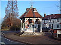
Ickenham Pump
This pump was the gift of Charlotte Gell in 1866 and was in use until December 1914. The pump itself and the octagonal timber framed canopy was restored in autumn 2003.
Image: © David Squire
Taken: 11 Dec 2005
0.02 miles
8
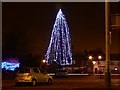
Illuminated tree, High Road, Ickenham
I think the tree is a permanent feature which has been decorated for the festive season. The viewpoint is Swakeleys Road. The tree is said to have been planted by the local Girl Guides Association many years ago.
Image: © Brian Robert Marshall
Taken: 16 Dec 2008
0.02 miles
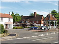
9

The Old Fox public house
High Road Ickenham
Image: © David Howard
Taken: 8 Mar 2011
0.02 miles
10

Ickenham village
Ickenham appears as 'Ticheham' in the Domesday Book of 1086 - see the Wiki entry https://en.wikipedia.org/wiki/Ickenham and http://www.british-history.ac.uk/vch/middx/vol4/pp100-102 . In the foreground (right) is Image; in the middle distance (left) is Image (photographed by David Hawgood).
Image: © Mike Quinn
Taken: 3 Feb 2016
0.03 miles