IMAGES TAKEN NEAR TO
Malcolm Road, UXBRIDGE, UB10 8ES
Introduction
This page details the photographs taken nearby to Malcolm Road, UB10 8ES by members of the Geograph project.
The Geograph project started in 2005 with the aim of publishing, organising and preserving representative images for every square kilometre of Great Britain, Ireland and the Isle of Man.

There are currently over 7.5m images from over14,400 individuals and you can help contribute to the project by visiting https://www.geograph.org.uk
Image Map
Images are licensed for reuse under creativecommons.org/licenses/by-sa/2.0
Notes
- Clicking on the map will re-center to the selected point.
- The higher the marker number, the further away the image location is from the centre of the postcode.
Image Listing (22 Images Found)
Images are licensed for reuse under creativecommons.org/licenses/by-sa/2.0
Image
Details
Distance
3
Witney Close, Ickenham
A short street off Woodstock Drive.
Image: © Des Blenkinsopp
Taken: 30 Mar 2016
0.08 miles
4
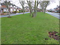
Campden Road, Ickenham
The estate here between Swakeleys Road and Swakeleys Park is rather lacking in greenery, but Swakeleys Park is close by. This green strip between two parts of Campden Road was about all I could find.
Image: © Marathon
Taken: 31 Jan 2018
0.10 miles
5

Foot and cycleway, Ickenham
The foot route is part of the Celandine Walk, which follows the River Pinn more or less closely from Pinner to the Grand Union canal at Cowley. It is usually a good deal more secluded than this part.
Image: © Robin Webster
Taken: 31 Aug 2014
0.12 miles
6
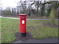
Pillar box in Warren Road
This is a very wintry scene. The woodland beyond is known as 'The Clump' and the River Pinn flows through it on the way out of the lake in Swakeleys Park. The River Pinn is a tributary of the Frays River which it joins at Yiewsley after passing through Ickenham and Uxbridge.
Image: © Marathon
Taken: 31 Jan 2018
0.12 miles
7
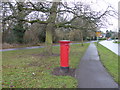
Warren Road
This is a very wintry scene. The woodland on the left is known as 'The Clump' and the River Pinn flows through it on the way out of the lake in Swakeleys Park. The River Pinn is a tributary of the Frays River which it joins at Yiewsley after passing through Ickenham and Uxbridge.
Image: © Marathon
Taken: 31 Jan 2018
0.13 miles
8
Campden Road, Ickenham
The estate here between Swakeleys Road and Swakeleys Park is rather lacking in greenery, but Swakeleys Park is close by. This green strip between two parts of Campden Road was about all I could find.
Image: © Marathon
Taken: 31 Jan 2018
0.13 miles
9
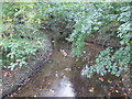
River Pinn in Ickenham
The River Pinn is a tributary of the River Colne and is viewed here looking downstream from the Swakeleys Drive road bridge.
Image: © Nigel Cox
Taken: 6 Oct 2007
0.17 miles
10

The lake in Swakeleys Park
Swakeleys was built between 1629 and 1638 and has been little changed since the 17th century. It is one of the finest Jacobean houses in London. A full history of the house can be seen at https://en.wikipedia.org/wiki/Swakeleys_House
Swakeleys Park is a part of the former Swakeleys Estate which covered 429 acres. This covered a substantial part of Ickenham which until the 20th century was totally rural with just a few hundred residents. Swakeleys House dominated the landscape and is still visible across the lake. The park itself was privately owned until the 1920s when it was conveyed to the Council to be preserved as public open space.
This view is near the southern entrance to the park as seen from Swakeleys Drive.
Image: © Marathon
Taken: 31 Jan 2018
0.18 miles