IMAGES TAKEN NEAR TO
Walnut Tree Close, UXBRIDGE, UB10 8AR
Introduction
This page details the photographs taken nearby to Walnut Tree Close, UB10 8AR by members of the Geograph project.
The Geograph project started in 2005 with the aim of publishing, organising and preserving representative images for every square kilometre of Great Britain, Ireland and the Isle of Man.

There are currently over 7.5m images from over14,400 individuals and you can help contribute to the project by visiting https://www.geograph.org.uk
Image Map
Images are licensed for reuse under creativecommons.org/licenses/by-sa/2.0
Notes
- Clicking on the map will re-center to the selected point.
- The higher the marker number, the further away the image location is from the centre of the postcode.
Image Listing (15 Images Found)
Images are licensed for reuse under creativecommons.org/licenses/by-sa/2.0
Image
Details
Distance

7
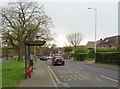
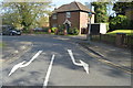
Bus stop and shelter on Swakeleys Road, Ickenham
Looking south west.
Image: © JThomas
Taken: 13 Apr 2019
0.18 miles
9
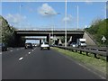
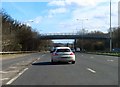
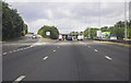
A40 - Swakeleys roundabout bridges
Simple structures with a central pillar, similar to the bridges at Target roundabout, Northolt (http://www.geograph.org.uk/photo/2357898).
Image: © Peter Whatley
Taken: 12 Apr 2011
0.21 miles