IMAGES TAKEN NEAR TO
Athol Way, UXBRIDGE, UB10 0LD
Introduction
This page details the photographs taken nearby to Athol Way, UB10 0LD by members of the Geograph project.
The Geograph project started in 2005 with the aim of publishing, organising and preserving representative images for every square kilometre of Great Britain, Ireland and the Isle of Man.

There are currently over 7.5m images from over14,400 individuals and you can help contribute to the project by visiting https://www.geograph.org.uk
Image Map
Images are licensed for reuse under creativecommons.org/licenses/by-sa/2.0
Notes
- Clicking on the map will re-center to the selected point.
- The higher the marker number, the further away the image location is from the centre of the postcode.
Image Listing (7 Images Found)
Images are licensed for reuse under creativecommons.org/licenses/by-sa/2.0
Image
Details
Distance
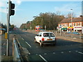
3
Uxbridge Road - Long Lane junction
Looking east
Image: © Ray Stanton
Taken: 21 Nov 2005
0.16 miles
5
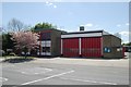
Hillingdon fire station
Hillingdon fire station, Uxbridge Road, London
Image: © Kevin Hale
Taken: 26 Apr 2009
0.23 miles
6
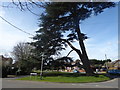
An impressive tree on Charville Lane West
This tree on Charville Lane West looks like a Cedar of Lebanon. It also looks like it has been severely trimmed in the past so it now appears a little lopsided.
Image: © Marathon
Taken: 14 Mar 2018
0.24 miles
7
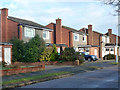
Houses on Chetwynd Drive
A turning off Vine Lane, Hillingdon.
Image: © Robin Webster
Taken: 18 Jan 2015
0.25 miles