IMAGES TAKEN NEAR TO
Burbridge Gardens, UXBRIDGE, UB10 0GE
Introduction
This page details the photographs taken nearby to Burbridge Gardens, UB10 0GE by members of the Geograph project.
The Geograph project started in 2005 with the aim of publishing, organising and preserving representative images for every square kilometre of Great Britain, Ireland and the Isle of Man.

There are currently over 7.5m images from over14,400 individuals and you can help contribute to the project by visiting https://www.geograph.org.uk
Image Map
Images are licensed for reuse under creativecommons.org/licenses/by-sa/2.0
Notes
- Clicking on the map will re-center to the selected point.
- The higher the marker number, the further away the image location is from the centre of the postcode.
Image Listing (29 Images Found)
Images are licensed for reuse under creativecommons.org/licenses/by-sa/2.0
Image
Details
Distance
1
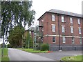
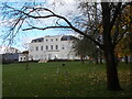
Barrack blocks at RAF Uxbridge
Two of the ten main barrack blocks built around the parade ground of RAF Uxbridge.
Image: © Ian Harrison
Taken: 22 Sep 2011
0.07 miles
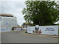
2
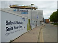
New housing development on the former RAF Uxbridge site
Image: © Rod Allday
Taken: 14 Apr 2017
0.13 miles
3
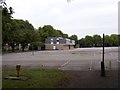
Queen's Colour Squadron building and parade ground
View of the Queen's Colour Squadron building and part of the parade ground of RAF Uxbridge.
Image: © Ian Harrison
Taken: 22 Sep 2011
0.14 miles

5
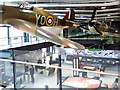
The Battle of Britain Bunker Exhibition and Visitor Centre, Uxbridge
Hillingdon Council acquired the Battle of Britain Bunker in 2015 from the Ministry of Defence and invested £6 million to create a permanent visitor centre at the site, which was opened in March 2018. The building provides a 2,000 square metre complex on two levels. Its design embraces the central themes of flight and aeroplanes including suspended Spitfire and Hurricane planes.
Image: © Andrew Curtis
Taken: 12 Oct 2019
0.15 miles
6
Dowding Park
A green space between roads on the Celandine Route.
Image: © Peter S
Taken: 22 Oct 2020
0.15 miles
7
St Andrew's Park housing development at former RAF Uxbridge
Image: © Rod Allday
Taken: 14 Apr 2017
0.16 miles
8
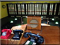
Battle of Britain underground Operations Room, Uxbridge
Image: © Andrew Curtis
Taken: 12 Oct 2019
0.16 miles
9
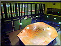
The No.11 Group Operations Room, Uxbridge
The Operations Room displayed various pieces of information in different ways, which the controller seated above the room behind curved, reflection-free glass would then use in order to make decisions. The location of formations of both enemy and friendly aircraft was displayed using numbered blocks on the map table below. Time was of the essence as enemy aircraft spotted in northern France by primitve long-range radar along the coast (the Chain Home system) could be over London within 20 minutes. The current activities of No.11 Group's squadrons e.g. 'At Standby', 'Enemy Sighted', 'Ordered to Land', etc. were displayed on the wall behind, the so-called 'tote board', using a series of lights. Current weather conditions at No.11 Group's sector stations were indicated with a system of coloured discs and the passage of time was tracked using a coordinated system of clock and coloured indicators. All information was received from either Fighter Command headquarters or the sector stations via telephone and teleprinter.
The operations room now has its 'tote board' and map table set as it was at 11:30am on the 15th September 1940, Battle of Britain Day.
There is another photo here: Image
Image: © Andrew Curtis
Taken: 12 Oct 2019
0.16 miles
10
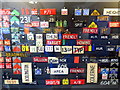
Tote Board Hooks, Battle of Britain Bunker
The metal letters, words and symbols were used to provide additional information on the 'Tote Board', the display on the rear wall of the underground operations room Image
Image: © Andrew Curtis
Taken: 12 Oct 2019
0.17 miles