IMAGES TAKEN NEAR TO
Vine Lane, UXBRIDGE, UB10 0BE
Introduction
This page details the photographs taken nearby to Vine Lane, UB10 0BE by members of the Geograph project.
The Geograph project started in 2005 with the aim of publishing, organising and preserving representative images for every square kilometre of Great Britain, Ireland and the Isle of Man.

There are currently over 7.5m images from over14,400 individuals and you can help contribute to the project by visiting https://www.geograph.org.uk
Image Map
Images are licensed for reuse under creativecommons.org/licenses/by-sa/2.0
Notes
- Clicking on the map will re-center to the selected point.
- The higher the marker number, the further away the image location is from the centre of the postcode.
Image Listing (34 Images Found)
Images are licensed for reuse under creativecommons.org/licenses/by-sa/2.0
Image
Details
Distance
2
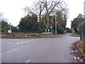
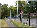
Junction of St Andrew's Road and Yew Tree Road
The Junction of St Andrew's Road and Yew Tree Road. The photograph is taken from St Andrew's Road, which also continues off left past the give way road markings. Yew Tree Road starts at the 10mph sign. The sign in the centre below the chevron sign points towards the road leading to the Battle of Britain Bunker.
Image: © Ian Harrison
Taken: 6 Jan 2013
0.09 miles
3
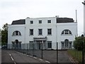
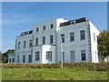
Hillingdon House
Hillingdon House, originally built in 1717 as a hunting lodge by the Duke of Schomberg. The current house was built in 1844 after the original burnt down.
Image: © Ian Harrison
Taken: 6 Jun 2011
0.09 miles
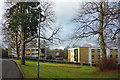
4
Hillingdon House
Hillingdon House is a Grade II listed mansion. The original house was built in 1717 as a hunting lodge for the Duke of Schomberg. It was destroyed by fire and the present house was built in its place in 1844. The British Government purchased Hillingdon House in 1915 and it became a military hospital. In 1917, what would become the Royal Air Force station RAF Uxbridge was established within the grounds. In military use, the house has served over time as the first headquarters for No. 11 Group RAF and RAF Bomber Command.
Image: © Rod Allday
Taken: 13 Nov 2021
0.10 miles
5
Old public footpath signs at RAF Uxbridge
Signs denoting the public footpath that ran through RAF Uxbridge until 1988. In 2011 a slightly rerouted version was opened.
Image: © Ian Harrison
Taken: 22 Sep 2011
0.11 miles
7
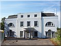
Hillingdon House
The Grade II listed Hillingdon House, within the grounds of the former RAF Uxbridge. This is due to be refurbished to include a restaurant under plans to redevelop the RAF Uxbridge site.
Built in 1844, the house replaced an earlier hunting lodge built in 1717 for the Duke of Schomberg.
Image: © Ian Harrison
Taken: 30 May 2012
0.12 miles
8
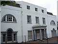
Hillingdon House
Hillingdon House, originally built in 1717 as a hunting lodge by the Duke of Schomberg. The current house was built in 1844 after the original burnt down.
Image: © Ian Harrison
Taken: 29 May 2011
0.12 miles
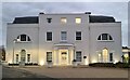
9
Hillingdon House, east facade
Rear of Hillingdon House, facing east.
Image: © Ian Harrison
Taken: 8 Sep 2012
0.13 miles
10
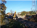
Demolition work at RAF Uxbridge
Building formerly known as "The Pub". A communications tower to the right, one of 3 on the site, will also be pulled down. This area of the station was once used by US intelligence.
Image: © Ian Harrison
Taken: 11 Nov 2012
0.13 miles