IMAGES TAKEN NEAR TO
Long Lane, UXBRIDGE, UB10 0AR
Introduction
This page details the photographs taken nearby to Long Lane, UB10 0AR by members of the Geograph project.
The Geograph project started in 2005 with the aim of publishing, organising and preserving representative images for every square kilometre of Great Britain, Ireland and the Isle of Man.

There are currently over 7.5m images from over14,400 individuals and you can help contribute to the project by visiting https://www.geograph.org.uk
Image Map
Images are licensed for reuse under creativecommons.org/licenses/by-sa/2.0
Notes
- Clicking on the map will re-center to the selected point.
- The higher the marker number, the further away the image location is from the centre of the postcode.
Image Listing (6 Images Found)
Images are licensed for reuse under creativecommons.org/licenses/by-sa/2.0
Image
Details
Distance
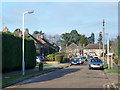
1
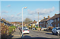
Snowden Avenue, Hillingdon
A gently sloping road down into the shallow valley of the Yeading Brook.
Image: © Des Blenkinsopp
Taken: 28 Nov 2017
0.16 miles
5
Cedars Drive, Hillingdon
One of several residential roads accessed from Vine Lane.
Image: © Robin Webster
Taken: 18 Jan 2015
0.24 miles
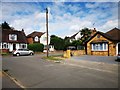
6
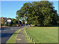
Court Drive, Hillingdon
Court Drive with Hillingdon Court Park on the right.
Image: © Alan Hunt
Taken: 6 Oct 2012
0.24 miles