IMAGES TAKEN NEAR TO
Nylands Avenue, RICHMOND, TW9 4HH
Introduction
This page details the photographs taken nearby to Nylands Avenue, TW9 4HH by members of the Geograph project.
The Geograph project started in 2005 with the aim of publishing, organising and preserving representative images for every square kilometre of Great Britain, Ireland and the Isle of Man.

There are currently over 7.5m images from over14,400 individuals and you can help contribute to the project by visiting https://www.geograph.org.uk
Image Map
Images are licensed for reuse under creativecommons.org/licenses/by-sa/2.0
Notes
- Clicking on the map will re-center to the selected point.
- The higher the marker number, the further away the image location is from the centre of the postcode.
Image Listing (178 Images Found)
Images are licensed for reuse under creativecommons.org/licenses/by-sa/2.0
Image
Details
Distance
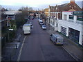
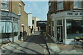
2
North Road Kew
From the bridge on High Park Road
Image: © David Howard
Taken: 30 Nov 2009
0.07 miles
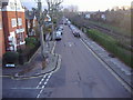
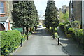
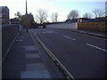
5
North Road Kew
Looking towards the station from the bridge in High Park Road
Image: © David Howard
Taken: 30 Nov 2009
0.08 miles
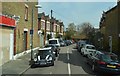
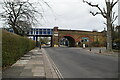
10
Railway Bridge, High Park Road
Unusually this bridge goes above North Road as well as the railway between Kew Gardens and Richmond stations
Image: © David Howard
Taken: 30 Nov 2009
0.10 miles