IMAGES TAKEN NEAR TO
Broomfield Road, RICHMOND, TW9 3HT
Introduction
This page details the photographs taken nearby to Broomfield Road, TW9 3HT by members of the Geograph project.
The Geograph project started in 2005 with the aim of publishing, organising and preserving representative images for every square kilometre of Great Britain, Ireland and the Isle of Man.

There are currently over 7.5m images from over14,400 individuals and you can help contribute to the project by visiting https://www.geograph.org.uk
Image Map
Images are licensed for reuse under creativecommons.org/licenses/by-sa/2.0
Notes
- Clicking on the map will re-center to the selected point.
- The higher the marker number, the further away the image location is from the centre of the postcode.
Image Listing (1017 Images Found)
Images are licensed for reuse under creativecommons.org/licenses/by-sa/2.0
Image
Details
Distance
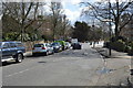
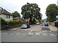
8
Sandycombe Road, Kew
Looking north up Sandycombe Road.
Image: © Christine Matthews
Taken: 18 Feb 2009
0.05 miles
9
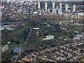
Kew Gardens from the air
With the River Thames and Brentford beyond.
Image: © Thomas Nugent
Taken: 28 Feb 2019
0.06 miles
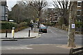
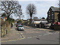
10
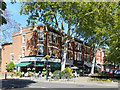
Cafe at Kew
On the corner of Station Approach. The area around Kew Gardens Station is a very pleasant urban village with local shops, cafes and small businesses in the shade of leafy plane trees.
Image: © Des Blenkinsopp
Taken: 13 May 2019
0.06 miles