IMAGES TAKEN NEAR TO
St. Pauls Road, RICHMOND, TW9 2HH
Introduction
This page details the photographs taken nearby to St. Pauls Road, TW9 2HH by members of the Geograph project.
The Geograph project started in 2005 with the aim of publishing, organising and preserving representative images for every square kilometre of Great Britain, Ireland and the Isle of Man.

There are currently over 7.5m images from over14,400 individuals and you can help contribute to the project by visiting https://www.geograph.org.uk
Image Map
Images are licensed for reuse under creativecommons.org/licenses/by-sa/2.0
Notes
- Clicking on the map will re-center to the selected point.
- The higher the marker number, the further away the image location is from the centre of the postcode.
Image Listing (118 Images Found)
Images are licensed for reuse under creativecommons.org/licenses/by-sa/2.0
Image
Details
Distance
1
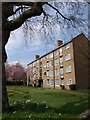
Flats on Stanford Gardens
One of four parallel blocks set obliquely to the road opposite Image
Image: © Derek Harper
Taken: 15 Apr 2010
0.02 miles
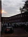
4
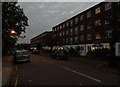
Stanmore Road at dusk
It was only about 4.40pm but that's the result of switching to GMT
Image: © David Howard
Taken: 5 Nov 2013
0.08 miles
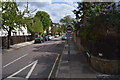
5
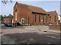
Raleigh Road United Church
From Stanmore Gardens the Raleigh Road United Church
Image: © Shaun Ferguson
Taken: 23 Apr 2009
0.08 miles