IMAGES TAKEN NEAR TO
Victoria Villas, RICHMOND, TW9 2GW
Introduction
This page details the photographs taken nearby to Victoria Villas, TW9 2GW by members of the Geograph project.
The Geograph project started in 2005 with the aim of publishing, organising and preserving representative images for every square kilometre of Great Britain, Ireland and the Isle of Man.

There are currently over 7.5m images from over14,400 individuals and you can help contribute to the project by visiting https://www.geograph.org.uk
Image Map
Images are licensed for reuse under creativecommons.org/licenses/by-sa/2.0
Notes
- Clicking on the map will re-center to the selected point.
- The higher the marker number, the further away the image location is from the centre of the postcode.
Image Listing (155 Images Found)
Images are licensed for reuse under creativecommons.org/licenses/by-sa/2.0
Image
Details
Distance
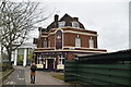
1
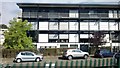
Office block, Victoria Villas, Richmond
Image: © Christopher Hilton
Taken: 8 Aug 2013
0.00 miles

4
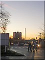
Richmond skyline, seen from Sainsbury's car park, Manor Road
The tower block is known simply as The Towers, and stands close to the A316. An evening photo, taken in the last week of November.
Image: © Stefan Czapski
Taken: 24 Nov 2014
0.06 miles
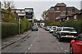
7
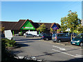
Homebase and Currys/PC World, Richmond, 2012
Off Manor Road.
Image: © Robin Webster
Taken: 22 Sep 2012
0.08 miles
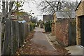
10

Calvert Court
A sheltered housing block at the end of Manor Park, Richmond.
Image: © Stephen Craven
Taken: 22 Jul 2010
0.08 miles