IMAGES TAKEN NEAR TO
Monmouth Grove, BRENTFORD, TW8 9QN
Introduction
This page details the photographs taken nearby to Monmouth Grove, TW8 9QN by members of the Geograph project.
The Geograph project started in 2005 with the aim of publishing, organising and preserving representative images for every square kilometre of Great Britain, Ireland and the Isle of Man.

There are currently over 7.5m images from over14,400 individuals and you can help contribute to the project by visiting https://www.geograph.org.uk
Image Map
Images are licensed for reuse under creativecommons.org/licenses/by-sa/2.0
Notes
- Clicking on the map will re-center to the selected point.
- The higher the marker number, the further away the image location is from the centre of the postcode.
Image Listing (70 Images Found)
Images are licensed for reuse under creativecommons.org/licenses/by-sa/2.0
Image
Details
Distance
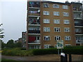
1
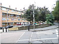
Flats on the corner of Clayponds Avenue and Occupation Lane
Image: © David Howard
Taken: 14 Sep 2013
0.01 miles
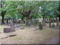
3
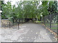
Path through South Ealing Cemetery from Occupation Lane
Image: © David Howard
Taken: 14 Sep 2013
0.03 miles
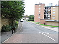
6
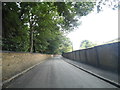
Occupation Lane, Ealing
The cemetery is behind the wall on the left, a housing estate on the right.
Image: © David Howard
Taken: 14 Sep 2013
0.07 miles
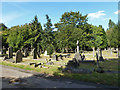
8

South Ealing Cemetery
Bluebell time in the cemetery.
Image: © Mark Percy
Taken: 19 Apr 2021
0.13 miles
9
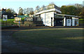
Clayponds Community Centre
On Clayponds Gardens.
Image: © Thomas Nugent
Taken: 24 Nov 2014
0.14 miles
10

Clayponds Community Centre
A colourful graffiti style mural on the wall of the community centre which is on Clayponds Gardens.
Image: © Thomas Nugent
Taken: 24 Nov 2014
0.14 miles