IMAGES TAKEN NEAR TO
Brentford Business Centre, Commerce Road, BRENTFORD, TW8 8LG
Introduction
This page details the photographs taken nearby to Brentford Business Centre, Commerce Road, TW8 8LG by members of the Geograph project.
The Geograph project started in 2005 with the aim of publishing, organising and preserving representative images for every square kilometre of Great Britain, Ireland and the Isle of Man.

There are currently over 7.5m images from over14,400 individuals and you can help contribute to the project by visiting https://www.geograph.org.uk
Image Map
Images are licensed for reuse under creativecommons.org/licenses/by-sa/2.0
Notes
- Clicking on the map will re-center to the selected point.
- The higher the marker number, the further away the image location is from the centre of the postcode.
Image Listing (302 Images Found)
Images are licensed for reuse under creativecommons.org/licenses/by-sa/2.0
Image
Details
Distance
1
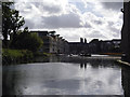
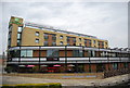
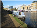
Brentford canal basin
Looking south as the Grand Union canal opens up into the canal basin. The dark outline on the far right is the edge of a dilapidated covered quay. The basin has been thoroughly redeveloped with the usual apartments.
Image: © Peter Jordan
Taken: 25 Sep 2005
0.07 miles
2
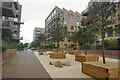
Apartments on Boaters Avenue
Part of the canalside development in Brentford. A show apartment used to sit in the foreground here but it has now been removed.
Image: © Bill Boaden
Taken: 26 May 2022
0.07 miles
3
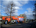
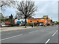
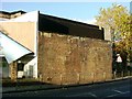
Still being Used
Not much remains of the old rail branch to Brentford docks. This is where it used to cross the road.
However, the brick arches which once supported the track have latterly proved more useful than the line itself and are still providing a premises for this motor business.
Nice bright colour too. Railway arches can often be so drab.
Image: © Des Blenkinsopp
Taken: 11 Feb 2010
0.08 miles
5
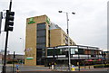
Brentford GWR railway station (site), Greater London
Opened in 1860 by the Great Western & Brentford Railway Company, later part of the Great Western Railway, on the line from Southall to Brentford Docks. This station was the passenger terminus and closed in 1942.
View north east from London Road. The viaduct spanned the road with the goods terminus at Brentford Dock being out of view to the right. See Image for a 1964 view from a slightly closer viewpoint.
For more information, see http://www.disused-stations.org.uk/b/brentford/index.shtml
Image: © Nigel Thompson
Taken: 8 Apr 2022
0.09 miles
6
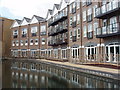
Flats by canal basin at Brentford
The commercial canal basin has become the pleasant foreground to new blocks of flats.
Image: © David Hawgood
Taken: 20 May 2008
0.09 miles
7
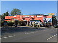
Carrera Worx, London Road, Brentford
Motor repairs and servicing business operating from former railway arches. See description here Image
Image: © Andrew Curtis
Taken: 20 Apr 2019
0.09 miles
8
Brimwylf, narrowboat moored in Brentford Lock basin
Brimwylf in Old English translates as "She-wolf of the sea".
Image: © David Hawgood
Taken: 2 Feb 2016
0.09 miles
9
Brentford branch viaduct, London Road
Part of an old branch line than ran from Southall to Brentford Dock,
this is the site of Brentford Town station on the GWR line,
the station was along the viaduct to the left of this picture.
Image: © Phillip Perry
Taken: 6 Nov 2007
0.09 miles