IMAGES TAKEN NEAR TO
Durham Wharf Drive, BRENTFORD, TW8 8HP
Introduction
This page details the photographs taken nearby to Durham Wharf Drive, TW8 8HP by members of the Geograph project.
The Geograph project started in 2005 with the aim of publishing, organising and preserving representative images for every square kilometre of Great Britain, Ireland and the Isle of Man.

There are currently over 7.5m images from over14,400 individuals and you can help contribute to the project by visiting https://www.geograph.org.uk
Image Map
Images are licensed for reuse under creativecommons.org/licenses/by-sa/2.0
Notes
- Clicking on the map will re-center to the selected point.
- The higher the marker number, the further away the image location is from the centre of the postcode.
Image Listing (357 Images Found)
Images are licensed for reuse under creativecommons.org/licenses/by-sa/2.0
Image
Details
Distance
1
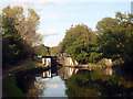
Approach to Clitheroe's Lock, Grand Union Canal
http://canalplan.eu/gazetteer/i9m7
Image: © Jim Osley
Taken: 20 Oct 2011
0.00 miles
2
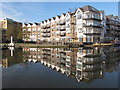
Apartments by Brentford Lock
The entrance to the lock is on the far left, by the white pillar. The flats are seen reflected in the canal basin.
Image: © David Hawgood
Taken: 24 Feb 2016
0.00 miles
3
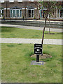
Canal milepost, Brentford
A number of these replica mileposts have been erected along the Grand Union Canal to replace ones which have disappeared over the years.
Image: © Alan Murray-Rust
Taken: 23 Jul 2008
0.01 miles
4

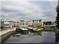
Durham Wharf
A housing and office development beside a small dock located off the main Brentford Basin. The development backs onto the road of the same name.
Image: © Martin Addison
Taken: 6 Apr 2012
0.02 miles

6
Brentford Locks - the start of the Grand Union Canal to Birmingham
Image: © Row17
Taken: 20 Apr 2006
0.02 miles
7
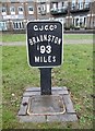
Replica milemarker by Grand Union Canal, Brentford
Replica milemarker by the Grand Union Canal, in parish of Brentford (Hounslow District), at Brentford Gauging Locks, next to towpath.
Inscription reads:-
G.J.C.C⁰.
BRAUNSTON
93
MILES
Plaque reads:-
LONDON BRANCH
IWA
1993
Surveyed
Milestone Society National ID: GUC-93R
Image: © Milestone Society
Taken: Unknown
0.02 miles
8

Brentford Gauging Locks
Commercial cargoes were once gauged (estimated) here, and tolls paid: http://www.waterscape.com/media/documents/22210.pdf
Image: © Mike Faherty
Taken: 5 Feb 2016
0.02 miles
9
View from the Toll Office
This was the office used by the boat gaugers who measured the displacement of the canal boats and calculated the tolls to be paid based on the loads being carried.
Some of the gauging staffs are on display, along with old pictures and ledgers etc.
The office has a wide view over the canal basin and is one of the few original buildings surviving in an area now all new apartments.
Image: © Des Blenkinsopp
Taken: 10 Nov 2016
0.02 miles
10
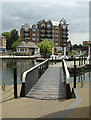
Swingbridge at Brentford Gauging Locks
This swing bridge is part of the canal towpath walk and spans a small basin of the main basin. I'm not sure whether it can still be operated.
Image: © Alan Murray-Rust
Taken: 23 Jul 2008
0.02 miles