IMAGES TAKEN NEAR TO
Lionel Road South, TW8 0RY
Introduction
This page details the photographs taken nearby to Lionel Road South, TW8 0RY by members of the Geograph project.
The Geograph project started in 2005 with the aim of publishing, organising and preserving representative images for every square kilometre of Great Britain, Ireland and the Isle of Man.

There are currently over 7.5m images from over14,400 individuals and you can help contribute to the project by visiting https://www.geograph.org.uk
Image Map
Images are licensed for reuse under creativecommons.org/licenses/by-sa/2.0
Notes
- Clicking on the map will re-center to the selected point.
- The higher the marker number, the further away the image location is from the centre of the postcode.
Image Listing (493 Images Found)
Images are licensed for reuse under creativecommons.org/licenses/by-sa/2.0
Image
Details
Distance
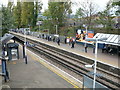
2
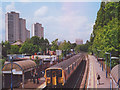
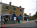
Kew Bridge station
South West Trains electric unit no 455741 calls at Kew Bridge station.
For another view of the station, attributed to the adjacent square (it lies on the grid line) see Image For another view of the towers in the background, see Image
Image: © Stephen Craven
Taken: 15 May 2003
0.02 miles
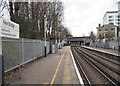
3
Kew Bridge Station
The sign below the station name reads "Alight here for the Royal Botanic Gardens" although the scrappy immediate environment of the station is not much like the famous gardens across the Thames at Kew.
Image: © David Martin
Taken: 11 Apr 2016
0.02 miles
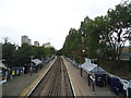
4
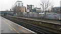
Kew Bridge station platforms
On the Hounslow Loop line.
Image: © Robin Webster
Taken: 9 Sep 2012
0.02 miles
6
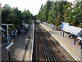
Kew Bridge railway station, London
Opened in 1849 by the London & South Western Railway on the line from London Waterloo to Feltham via the Hounslow loop. View east towards Chiswick and London.
Image: © Nigel Thompson
Taken: 17 Dec 2010
0.02 miles
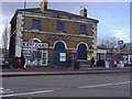
8
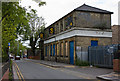
Stratton Gentry, Lionel Road South
The one-time coal office situated in the triangle of the railway tracks at Kew Bridge. It has seen subsequent use by RSR Fasteners, who have since moved to Hayes in Middlesex. The area behind, which presumably was once used to store coal, holds piles of hardcore for London's building sites.
Image: © Martin Addison
Taken: 7 May 2010
0.02 miles
10

Brentford Community Stadium from the air
Less than a mile from Griffin Park Image, the new home of Brentford FC is nearing completion. Part of a wider redevelopment scheme, the 17,250 seat stadium will also host rugby matches.
Further details: https://newstadium.brentfordfc.com/stadium and https://www.brentfordcommunitystadium.com/ .
The site is within a triangle formed by the M4 Great West Road and two railway lines.
The tower (and its shadow) at the London Museum of Water and Steam can be seen in the lower left corner.
Seen from a Heathrow bound flight from Prague.
Image: © Thomas Nugent
Taken: 7 Jan 2020
0.03 miles