IMAGES TAKEN NEAR TO
Pump Alley, BRENTFORD, TW8 0AE
Introduction
This page details the photographs taken nearby to Pump Alley, TW8 0AE by members of the Geograph project.
The Geograph project started in 2005 with the aim of publishing, organising and preserving representative images for every square kilometre of Great Britain, Ireland and the Isle of Man.

There are currently over 7.5m images from over14,400 individuals and you can help contribute to the project by visiting https://www.geograph.org.uk
Image Map (Loading...)


Getting Data...Please wait
Leaflet Map data © OpenStreetMap
Images are licensed for reuse under creativecommons.org/licenses/by-sa/2.0
Notes
- Clicking on the map will re-center to the selected point.
- The higher the marker number, the further away the image location is from the centre of the postcode.
Image Listing (371 Images Found)
Images are licensed for reuse under creativecommons.org/licenses/by-sa/2.0
Image
Details
Distance
1
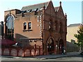
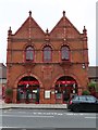
The Old Fire Station, Brentford
The old fire station on Brentford High Street has been turned into a bar & restaurant, called The Old Fire Station.
I can't tell you anything about the quality of their food & drink, but they have a nice website http://www.the-firestation.co.uk/
Image: © Rich Tea
Taken: 20 Oct 2007
0.02 miles
2

St Paul's Primary School - Brentford
Image: © Anthony Parkes
Taken: 14 Sep 2024
0.03 miles
3
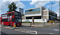
Brentford County Court along the High Street
Image: © Mat Fascione
Taken: 21 Aug 2015
0.04 miles
4
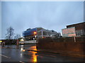
Brentford County Court and Alexandra House
Alexandra House is for the local social services, while the court is being renovated.
Image: © David Howard
Taken: 25 Jan 2014
0.04 miles
5
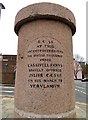
The Memorial Column on High Street
It reads "B.C.54 AT THIS ANCIENT FORTIFIED FORD THE BRITISH TRIBESMEN UNDER CASSIVELLAVNVS BRAVELY OPPOSED JVLIVS CAESAR ON HIS MARCH TO VERVLAMIVM".
Image: © Steve Daniels
Taken: 5 Jan 2019
0.05 miles
6
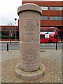
The Memorial Column on High Street
It reads, "A.D. 1642 CLOSE BY WAS FOVGHT THE BATTLE OF BRENTFORD BETWEEN THE FORCES OF KING CHARLES I AND THE PARLIAMENT"
Image: © Steve Daniels
Taken: 5 Jan 2019
0.05 miles
7
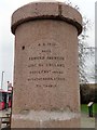
The Memorial Column on High Street
It reads, "A.D. 1016 HERE EDMVND IRONSIDE KING OF ENGLAND DROVE CNVT AND HIS DEFEATED DANES ACROSS THE THAMES".
Image: © Steve Daniels
Taken: 5 Jan 2019
0.05 miles
8
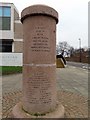
The Memorial Column on High Street
It reads, "A.D. 780-1 NEAR BY OFFA KING OF MERCIA WITH HIS QVEEN THE BISHOPS AND PRINCIPAL OFFICERS HELD A COVNCIL OF THE CHVRCH".
Image: © Steve Daniels
Taken: 5 Jan 2019
0.05 miles
9
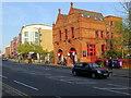
Former Fire Station, High Street, Brentford
Fire station, now office, 1897 by T H Nowell Parr for Brentford District Council.
Grade II Listed Building (List Entry Number: 1096874) https://historicengland.org.uk/listing/the-list/list-entry/1096874
Image: © Andrew Curtis
Taken: 19 Apr 2019
0.06 miles
10
The old fire station on High Street
The Old Fire Station has been converted to a restaurant.
Image: © Steve Daniels
Taken: 5 Jan 2019
0.06 miles