IMAGES TAKEN NEAR TO
South Street, ISLEWORTH, TW7 7AL
Introduction
This page details the photographs taken nearby to South Street, TW7 7AL by members of the Geograph project.
The Geograph project started in 2005 with the aim of publishing, organising and preserving representative images for every square kilometre of Great Britain, Ireland and the Isle of Man.

There are currently over 7.5m images from over14,400 individuals and you can help contribute to the project by visiting https://www.geograph.org.uk
Image Map
Images are licensed for reuse under creativecommons.org/licenses/by-sa/2.0
Notes
- Clicking on the map will re-center to the selected point.
- The higher the marker number, the further away the image location is from the centre of the postcode.
Image Listing (129 Images Found)
Images are licensed for reuse under creativecommons.org/licenses/by-sa/2.0
Image
Details
Distance

3
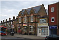
Isleworth Hall
Grade II listed. http://www.britishlistedbuildings.co.uk/en-469250-isleworth-public-hall-hounslow
Image: © N Chadwick
Taken: 7 May 2011
0.04 miles
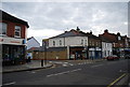
7
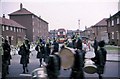
Girl Pipers in Magdala Road
Whilst taking part in a Pageant through Isleworth, a band of Girl Pipers are pictured turning into Magdala Road, Isleworth, which lies between Richmond Road and Worple Road. The 'bus in the background is an RT and believed to be at a layover point, just off the Route 37 (Hounslow to Peckham).
Image: © Clive Warneford
Taken: Unknown
0.05 miles

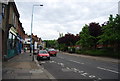
10
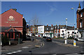
South Street
The A3004 seen at the junction with Richmond Road and Lion Wharf Road. On the left is Upper Square.
Image: © Martin Addison
Taken: 6 Apr 2012
0.06 miles