IMAGES TAKEN NEAR TO
Church Street, ISLEWORTH, TW7 6XB
Introduction
This page details the photographs taken nearby to Church Street, TW7 6XB by members of the Geograph project.
The Geograph project started in 2005 with the aim of publishing, organising and preserving representative images for every square kilometre of Great Britain, Ireland and the Isle of Man.

There are currently over 7.5m images from over14,400 individuals and you can help contribute to the project by visiting https://www.geograph.org.uk
Image Map
Images are licensed for reuse under creativecommons.org/licenses/by-sa/2.0
Notes
- Clicking on the map will re-center to the selected point.
- The higher the marker number, the further away the image location is from the centre of the postcode.
Image Listing (267 Images Found)
Images are licensed for reuse under creativecommons.org/licenses/by-sa/2.0
Image
Details
Distance
1
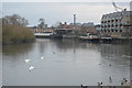
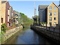
The Thames foreshore at the outfall of the Duke of Northumberland's River
Looking south, and upstream, at low tide. In the right foreground, 'white water' marks the outfall of one of London's man-made rivers - in this case, the Duke of Northumberland's. (Others that might be mentioned are Lord Longford's - quite a feature in Bushy Park - and the New River, flowing through North London).
The shore on the left of the picture is that of Isleworth Ait, a long narrow island. The main channel of the Thames flows along the far side of the Ait - the stretch of water seen here is a subsidiary channel.
Notice that the vessel on the right - it looks like a Dutch motor barge - is resting on stanchions, and shackled in place.
Image: © Stefan Czapski
Taken: 10 Jan 2011
0.01 miles

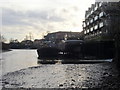
3
Duke of Northumberland's river meets the Thames
Image: © David Howard
Taken: 20 Oct 2008
0.02 miles
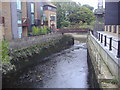
4
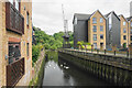
Mill Basin (River Crane), Isleworth
Grade II listed. http://www.britishlistedbuildings.co.uk/en-488069-mill-bridge-and-basin-hounslow
Image: © N Chadwick
Taken: 7 May 2011
0.02 miles
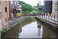
5
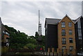
Duke of Northumberland's River
Here it flows into the River Thames. It is viewed from Church Street. Isleworth Ait is straight ahead.
Image: © Bill Boaden
Taken: 26 May 2022
0.02 miles

8
Crane, Mill Basin (River Crane), Isleworth
Image: © N Chadwick
Taken: 7 May 2011
0.02 miles
9
Duke of Northumberland's River, Isleworth
The Duke of Northumberland's River or D. O. N. River consists of separate upper and lower artificial watercourses in west London and would more accurately be called Isleworth Mill Stream/River as the motive for its construction.
https://en.wikipedia.org/wiki/Duke_of_Northumberland%27s_River
Image: © Andrew Curtis
Taken: 20 Apr 2019
0.03 miles