IMAGES TAKEN NEAR TO
Malting Way, ISLEWORTH, TW7 6SD
Introduction
This page details the photographs taken nearby to Malting Way, TW7 6SD by members of the Geograph project.
The Geograph project started in 2005 with the aim of publishing, organising and preserving representative images for every square kilometre of Great Britain, Ireland and the Isle of Man.

There are currently over 7.5m images from over14,400 individuals and you can help contribute to the project by visiting https://www.geograph.org.uk
Image Map
Images are licensed for reuse under creativecommons.org/licenses/by-sa/2.0
Notes
- Clicking on the map will re-center to the selected point.
- The higher the marker number, the further away the image location is from the centre of the postcode.
Image Listing (67 Images Found)
Images are licensed for reuse under creativecommons.org/licenses/by-sa/2.0
Image
Details
Distance
3
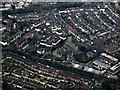
Isleworth from the air
St John The Baptist church http://stjohnsisleworth.org.uk/ is prominent. Taken from a Heathrow bound flight from Glasgow.
Image: © Thomas Nugent
Taken: 16 Feb 2015
0.17 miles
7
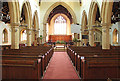
St John the Baptist, Isleworth - East end
Image: © John Salmon
Taken: 22 Jul 2014
0.18 miles
8
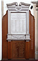
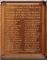
St John the Baptist, Isleworth - War Memorial WWI & WWII
Image: © John Salmon
Taken: 22 Jul 2014
0.18 miles
9
St John the Baptist, Isleworth - War Memorial WWII
Image: © John Salmon
Taken: 22 Jul 2014
0.18 miles
10
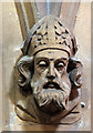
St John the Baptist, Isleworth - Label head
Image: © John Salmon
Taken: 22 Jul 2014
0.18 miles