IMAGES TAKEN NEAR TO
Castle Road, ISLEWORTH, TW7 6QS
Introduction
This page details the photographs taken nearby to Castle Road, TW7 6QS by members of the Geograph project.
The Geograph project started in 2005 with the aim of publishing, organising and preserving representative images for every square kilometre of Great Britain, Ireland and the Isle of Man.

There are currently over 7.5m images from over14,400 individuals and you can help contribute to the project by visiting https://www.geograph.org.uk
Image Map
Images are licensed for reuse under creativecommons.org/licenses/by-sa/2.0
Notes
- Clicking on the map will re-center to the selected point.
- The higher the marker number, the further away the image location is from the centre of the postcode.
Image Listing (106 Images Found)
Images are licensed for reuse under creativecommons.org/licenses/by-sa/2.0
Image
Details
Distance
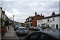
4
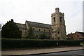
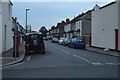
St. John the Baptist Church, Isleworth
On St. Jon's Road
Image: © Dr Neil Clifton
Taken: 6 Mar 2008
0.07 miles
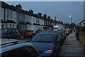
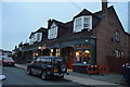
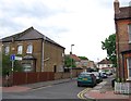
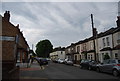
5
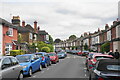
Linkfield Road
A residential road where parking is a continual issue, a not uncommon situation.
Image: © Bill Boaden
Taken: 26 May 2022
0.08 miles
7
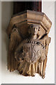
St John the Baptist, Isleworth - Corbel angel
Image: © John Salmon
Taken: 22 Jul 2014
0.08 miles
10
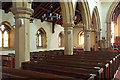
St John the Baptist, Isleworth - North arcade
Image: © John Salmon
Taken: 22 Jul 2014
0.08 miles