IMAGES TAKEN NEAR TO
Woodlands Grove, ISLEWORTH, TW7 6NS
Introduction
This page details the photographs taken nearby to Woodlands Grove, TW7 6NS by members of the Geograph project.
The Geograph project started in 2005 with the aim of publishing, organising and preserving representative images for every square kilometre of Great Britain, Ireland and the Isle of Man.

There are currently over 7.5m images from over14,400 individuals and you can help contribute to the project by visiting https://www.geograph.org.uk
Image Map
Images are licensed for reuse under creativecommons.org/licenses/by-sa/2.0
Notes
- Clicking on the map will re-center to the selected point.
- The higher the marker number, the further away the image location is from the centre of the postcode.
Image Listing (80 Images Found)
Images are licensed for reuse under creativecommons.org/licenses/by-sa/2.0
Image
Details
Distance
1
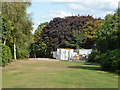
A way out of Thornbury Park
To St. John's Road after threading through an industrial estate.
Image: © Robin Webster
Taken: 22 Sep 2012
0.05 miles
2
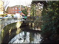
Duke of Northumberland's River
The river turns sharply from flowing north to flowing east at this point and within a mile drains into the Thames at the site of what was one of the largest flour mills near London.
Image: © David Squire
Taken: 2 Dec 2005
0.13 miles
3
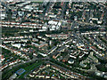
Isleworth from the air
St John The Baptist church http://stjohnsisleworth.org.uk/ is in the lower right corner. Taken from a Heathrow bound flight from Glasgow.
Image: © Thomas Nugent
Taken: 18 Mar 2014
0.13 miles
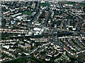
4
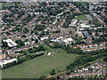
Thornbury Playing Fields from the air
Heston and Isleworth fire station and West Thames College can also be seen.
Image: © Thomas Nugent
Taken: 3 Aug 2015
0.14 miles
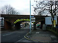
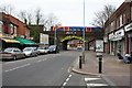
6
St. John's Rd. bridge, Isleworth
Nothing really amazing about this railway bridge close to Isleworth station, other than the fact, that it's in the top 10 most struck bridges in the country.
Image: © Phillip Perry
Taken: 19 Nov 2012
0.15 miles
7
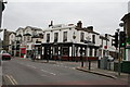
The 'Woodlands' Tavern, Isleworth
At the junction of Woodlands Road with St. John's Road. It looked inviting, but I did not have time to try it.
Image: © Dr Neil Clifton
Taken: 6 Mar 2008
0.15 miles
8
Isleworth from the air
St John The Baptist church http://stjohnsisleworth.org.uk/ is in the lower right corner. Taken from a Heathrow bound flight from Glasgow.
Image: © Thomas Nugent
Taken: 18 Mar 2014
0.15 miles
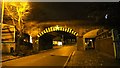
9
Railway bridge over St. John's Road, Isleworth
This is part of the B363. A Class 450 'Desiro' unit of South West Trains is visible as it calla at Isleworth station.
Image: © Dr Neil Clifton
Taken: 6 Mar 2008
0.15 miles
10
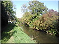
Duke of Northumberland's River at Woodlands, Isleworth
In the area known as Woodlands, the road ahead is appropriately called Riverside Walk. This section of the Duke of Northumberland's River dates from the time of Syon Abbey and supplied water to the mill at Isleworth and later to the ornamental ponds in the Duke of Northumberland's estate at Syon.
Image: © Marathon
Taken: 20 Oct 2010
0.15 miles