IMAGES TAKEN NEAR TO
Abinger Gardens, ISLEWORTH, TW7 6LH
Introduction
This page details the photographs taken nearby to Abinger Gardens, TW7 6LH by members of the Geograph project.
The Geograph project started in 2005 with the aim of publishing, organising and preserving representative images for every square kilometre of Great Britain, Ireland and the Isle of Man.

There are currently over 7.5m images from over14,400 individuals and you can help contribute to the project by visiting https://www.geograph.org.uk
Image Map
Images are licensed for reuse under creativecommons.org/licenses/by-sa/2.0
Notes
- Clicking on the map will re-center to the selected point.
- The higher the marker number, the further away the image location is from the centre of the postcode.
Image Listing (14 Images Found)
Images are licensed for reuse under creativecommons.org/licenses/by-sa/2.0
Image
Details
Distance
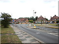
3
Green between Farnell Road and Bridge Road
Image: © David Howard
Taken: 27 Apr 2013
0.11 miles
5
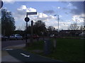
Farnell Road at the junction of Worton Road
Image: © David Howard
Taken: 27 Apr 2013
0.15 miles
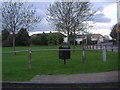
6
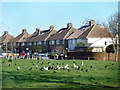
Birds on the Lawn
A small strip of park along the west side of Farnell Road.
Image: © Des Blenkinsopp
Taken: 8 Jan 2019
0.16 miles
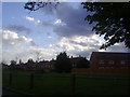
7
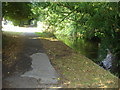
Riverside Walk, Isleworth
The Duke of Northumberland's river
Image: © David Howard
Taken: 8 Aug 2010
0.16 miles

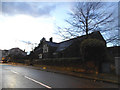
9
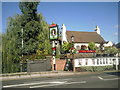
The Royal Oak, Worton Road, Isleworth
One of many pubs which refer to the English oak tree within which the future King Charles II hid to escape the Roundheads following the Battle of Worcester in 1651. The pub sign features the head of Charles within the tree. The photograph is taken from the bridge over the Duke of Northumberland's River.
Image: © Marathon
Taken: 20 Oct 2010
0.18 miles
10
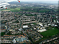
Hounslow from the air
Lampton is to the left, Spring Grove to the right.
Image: © Thomas Nugent
Taken: 18 Mar 2014
0.19 miles